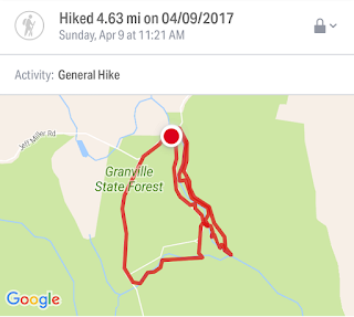
Estimated distance: 4.63 miles
Weather: 63°F, clear
Resources: Granville State Forest, Trail Map
Highlights of the trip: waterfalls
Progress toward 2017 Outdoor Goals: 13/52 hikes; 40.22/250 miles hiked
A glorious day for a hike! My hiking partner, her husband, and I headed off to Granville State Forest in Massachusetts.
We started our hike by walking along the east side of the Hubbard River. There was plenty of water flowing and it made for a beautiful hike.
We went as far south along the river as the cut that has been made for the pipeline. We turned back and then followed the trail along the western side of the river. On this side, you are not as close to the river, but there are a few spots that allow you to go out and look at the water. My friend's husband was able to find some geocaches on this side of the river that had eluded him on our previous hike here.
We followed the trail to a bridge over Halfway Brook, which flows into Hubbard River, and then headed west to West Hartland Road. Not a geocache, but my friend and I found some moose scat along here and thought that was a pretty cool thing to find. We got to the road and walked back to our car.
 |
| Halfway Brook |
Although I like hiking in new places, it is also nice to have some "go-to" trails that don't require a lot of planning. I think Granville has become one of those trails.


No comments:
Post a Comment