Bryce Canyon National Park
Today we awoke to a beautiful, sunny day. Granted, still quite cold, but we'll take it.
One thing I forgot to mentioned in the previous post is that we came up with a name for our rental van. After enduring the brutal winds and freezing cold on Wednesday, we named the van "Zion" for "place of refuge".
This morning, we headed toward the park, but stopped first at Fairyland Point. There is an 8.2 mile loop trail that starts here, but that was not on our agenda. Instead, we ventured a short distance down the trail, just to get a little closer to the hoodoos, those strange rock spires that Bryce is known for.
 |
| View at Fairyland Point. |
One of the first things we noticed was the...mud. I guess that is what I will call it. When you looked at the ground, it looked like little pebbles or clumps of sand that had eroded from the canyon. Once you stepped on it though, you found it was this really gloppy mess that stuck to your boots like glue. The more steps you took, the thicker it got, until you felt like you had another pair of shoes on your shoes. The stuff just did not come off! It also made the trail rather slick, and this may be why the ranger had told us he had heard that people had been falling yesterday. I thought it was due to ice. Now, I think it was because of this mud.
When we got back to the car, we used extra precautions to keep it clean. There is a sticker on the window warning us of extra charges if the car is excessively dirty. So, Dave and I flipped over our floor mats to the rubber side and the boys used plastic bags and newspapers to keep the area under their feet clean.
 |
| Mud? |
 |
| Bill has an extra layer of sole. |
Next stop was the Visitor Center to talk with the ranger about doing the Navajo/Queen's Garden loop. We had been dissuaded from doing it yesterday, which was fine, but we only had today and I wanted to get into the canyon. While waiting at the counter, who do you think we ran into again? Yes, our friends from Vermont. They ignored the ranger and did the Queen's Garden Loop on Wednesday and said it was really beautiful with the snow.
Today, there was a different ranger and she seemed to have no qualms about people going into the canyon. She suggested a different route, though. One that she preferred. She suggested the Navajo/Peekaboo Combination Loop and said we could even add the Queen's Garden if we wanted on our way back. The Peekaboo Loop is a 3-mile loop that is also one of the horse trails. It takes you into the heart of the Bryce Amphitheater. Our friends from Vermont listened in, but they decided to do the Fairyland Loop today. They have another day here and will do Peekaboo tomorrow.
We headed down the trail for the Navajo Loop that starts at Sunset Point. The Wall Street section of the trail is closed, so you can't actually make a loop out of this right now. You have to either go up the same way you went down, or continue to another trail.
The trail switchbacks down to the bottom. It still amazes me to see what some people are wearing on the trail. I'm not saying they need to be all decked out in hiking gear if they are just going down this little section of trail, but some don't even have sneakers on. Some of the women were wearing flats or I swear one woman was wearing espadrilles. The mud wasn't as bad as at Fairyland Point, but her shoes still must have been completely ruined.
 |
| Down the switchbacks of the Navajo Loop trail. |
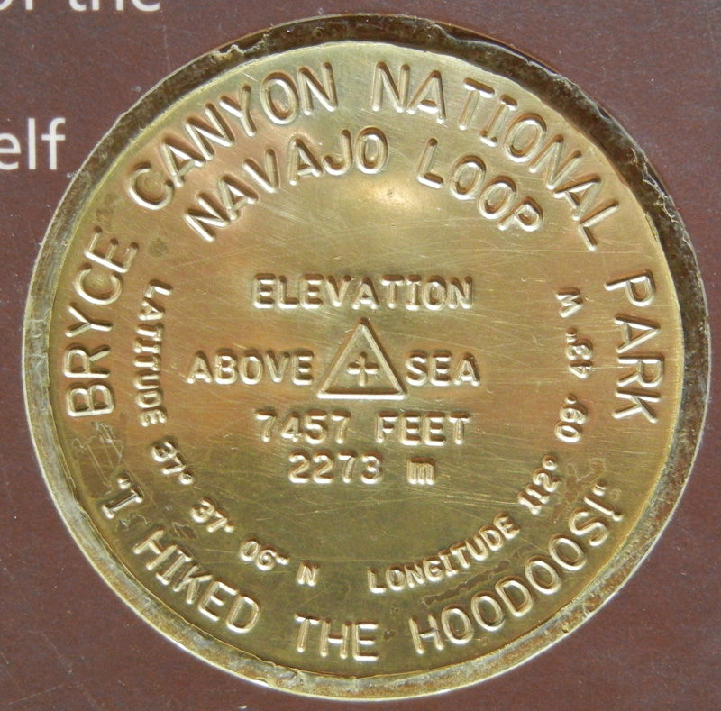 |
| Me and my benchmarks, though this is on a sign post rather than embedded in the rock. |
When we got to the bottom, we decided to take the short spur over to the Wall Street area that was closed. You could look up through the slot, but there were signs warning you to go no farther. There looked like there was fallen rock.
 |
| Near Wall Street. |
 |
| Closed. Though it looks like the steps were blocked, I don't think they were. |
 |
| I think these benchmarks were part of some Junior Ranger Activity. You had to collect 3 to prove you hiked the hoodoos. |

 |
| Steller's Jay chick. We thought it was alone at first, but then mom came back and made herself known. |
In one area, we came to a trail that connected with Bryce Point. We had been there yesterday and had seen what is called the Wall of Windows - arches cut in the hoodoos. Now we were below those windows looking up.

 |
| Wall of Windows. |
The Peekaboo Loop is listed as strenuous, but if I can do it, anyone can. It just has a lot of up and downs and is one of those trails where you think you have made it to the top, only to realize that it goes back down and then up again! About half-way around the loop, we came to a place where they water the horses and have an outhouse - thank goodness! Even on the way down the Navajo Trail, two miles ago, I had been wishing that I had not had my usual mug of tea for breakfast. Although I had been enjoying the hike thus far, I had also been spending some time contemplating where I could steal away for a pit stop. It's hard to tell where there is a secluded spot because you have to remember there are people on the overlooks above you. Anyway, relief! (TMI, I am sure.)
The hike was spectacular, and again, I emphasize listening to what the rangers suggest. They really know their stuff. By the time we got back to the bottom of the Navajo Trail, no one was that interested in continuing on the Queen's Garden Loop. That was fine with me. My main goal had been to get us down below the rim of the canyon and in among the hoodoos and we had accomplished that. In all, with the spur to Wall Street, we had hiked over 5 miles.
We ate lunch at the Bryce Canyon Lodge (no view over the canyon) and just made it in before they shut down at 3 o'clock. Afterward, we got on the road back to Zion and were in Springdale by 5:30. We got the same room we had at the beginning of the week. Dave and Billy went to use the pool and the hot tub and then we went to dinner at Casa de Amigos. The food was okay, but not fantastic. I ordered a Margarita and was told that due to state liquor law, if I wanted it frozen, it could only have one shot of alcohol in it. I guess if I had it on the rocks, I could have two, but doing a quick Google search makes me wonder about that. It seems like maybe they could make me a Margarita with one shot and then they would have to bring the other on the side. Although, something else I read made it seem like they could not bring me tequila on the side, it would have to be some other liquor. Crazy Utah liquor law looks like a fun topic to explore further, but I won't.
 |
| Desert bighorn sheep by the side of the road as we waited to go through the Zion-Mt. Carmel tunnel on our way back to Springdale. |


