Showing posts with label Bloomfield. Show all posts

Wednesday, July 25, 2018

Auer Farm - Bloomfield, CT

Date Hiked: Wednesday, June 6, 2018
Estimated distance:  2.48 miles
Weather: 65°F, scattered clouds
Resources: Auerfarm, Auerfarm State Park Scenic Reserve, CTMQ
Highlights of the trip:  views
Progress toward NET Hike 50 Challenge: 10.5/50 miles completed

Playing catch-up blogging about my hikes.

In June, I joined the Take a Hike! Farmington Valley facebook group on a hike at Auerfarm.  Auerfarm is Connecticut's newest state park and it is well worth a visit.  This hike would be a nice one to do as a family, especially if you take the kids to visit the animals afterward.


We started our hike from the parking lot near the education buildings and walked back down the road to the turn off for the trail that goes up the hill.  For a shorter hike, there is parking near the trail.


When we reached the top of the hill, we followed the road around to a couple of abandoned cabins.  I love finding these old places, but it also makes me a little sad that they have fallen into ruin.


We then headed back to the mown trails that went across the fields.  The view from up here is spectacular and I was thrilled to find that I could see the Heublein Tower from the eastern side.

Heublein Tower is visible about a quarter of the way from the left hand side of the picture.

Check out that view looking north along the Metacomet Ridge!

We passed an apple orchard on our way down the hill back to the road.


 I highly recommend this hike and I am surprised it took me so long to get here.  I will be back.

Wednesday, June 28, 2017

Connecticut Hiking Trails by Town - Bloomfield

CT > Hartford County > Bloomfield

Penwood State Park

Looking from Penwood south along Metacomet to the Heublein Tower on Talcott Mountain.
The Metacomet Trail runs through the center of Penwood State Park.  There are at least 4 miles of trails here to explore.

DEEP Penwood State Park, Trail Map
The A to Z of Connecticut State Parks blog post (29 Nov 2015)
Along the New England Trail blog post (25 Sep 2012)

Included in the following books:
50 Hikes in Connecticut (4th Edition) by David, Gerry, and Sue Hardy
Connecticut Walk Book (20th Edition) by Connecticut Forest and Park Association

Metacomet Trail

CFPA Interactive Trail Map
CT NET: Section 18


Marion K. Wilcox Park

This park in the northern part of Bloomfield connects to the Metacomet Trail.  There are over 5 miles of trails.

Marion K. Wilcox Trail Map
OpenStreetMap
This Outdoor Life blog post (5 Dec 2009)
Hartford Courant Article (7 Feb 2013) by Peter Marteka
Along the New England Trail blog post (1 Oct 2012)


Farmington River Park

I believe this park is owned by the town of Bloomfield.  As the name suggests, it borders the Farmington River and is between Tarrifville Gorge and Rainbow Reservoir.  I have not been able to find any trail maps, but suggest looking at the OpenStreetMap listed below.

Farmington Valley Homeschool Hikers blog post (29 Mar 2013)
David Reik blog post (14 Jun 2017)
OpenStreetMap with information provided by David Reik

Seabury Wildwoods Trails

Seabury is an Active Life Care Community.

Trail Map
OpenStreetMap


Auerfarm State Park Scenic Reserve

CT Woodlands description
CTMQ blog post (5 Jan 2016)
Hartford Courant Article (14 May 2016) by Peter Marteka
OpenStreetMap


Other Information

Map of protected open space in Bloomfield
Wintonbury Land Trust
Wintonbury Land Trust Facebook
Map of Wintonbury Land Trust Properties

There are a couple of properties that I think may have some trails and may connect to each other, but I can't find any maps online.  They are the Wintonbury Land Trust's Sinnott Farm property and the town's LaSallette Park property.  I believe hikes on these properties have been offered on Trail Days in June.


Monday, October 17, 2016

Hike #48: Penwood State Park - Bloomfield, CT

Date Hiked: Monday, October 10, 2016
Estimated distance: 4.43 miles
Weather: 53°F, sunny
Resources: Penwood State Park, Trail Map
Highlights of the trip:  view
Progress toward 2016 hiking goals:  48/52 hikes; 180.13/250 miles; 31.37/25 miles on Tunxis Trail


Another beautiful October day!  It has been almost a year since I have been to Penwood, and with the foliage starting to show, I figured it was time for another trip.  Last time, I thought I had hiked 6.5 miles, but since I took the same route today and it was under 5 miles, I was obviously mistaken.  I think I used the trail map to figure mileage last time and must have double counted the stretch along the Metacomet.


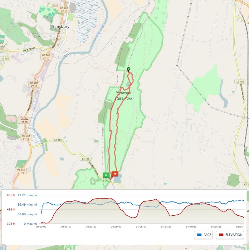
The above map comes from my MapMyHike app.  I wish I could get a screenshot zoomed in closer, but then I don't get the whole map.  I like the detail that the OpenStreetMap provides, but as far as I can tell, I do not have the option to view it that way while I am hiking.  Once I get home and check the hike on the computer, I can change the map options to OpenStreetMap.

Along the Metacomet Trail.

Part way along the Metacomet Trail, there is a little area off to the side where people have stacked rocks.  It is really interesting.  I believe there are little notes tucked in between some of the rocks in remembrance of loved ones.


The trail took me down to the road (closed to cars) near Lake Louise.


From Lake Louise, I continued on the Metacomet and climbed the "stairs" up to the Pinnacle.  The view up here is tremendous.  Looking south along the ridge, I could see the Heublein Tower in nearby Talcott Mountain State Park.  To the left of that, I could make out a series of hills in the distance.  It was funny, but my PeakFinder app wasn't labeling all of them.  From west to east, I think I was seeing Lamentation Mountain, Beseck Mountain, and Mount Higby.  Not 100 percent sure, but that's my guess.

Looking south at Talcott Mountain and the Heublein Tower.

I took the road down from the Pinnacle and continued to follow it past Lake Louise and around the west side of the park.  I left the road to go a short distance on the yellow trail which also offered some nice views of the valley.


I recommend taking the Metacomet, at least in one direction, to avoid some of the "crowds".  The parking lot was pretty full when I arrived and jam-packed when I got back, with people parked up on the grass.  I saw only two people while I was on the Metacomet and only a couple more at the Pinnacle.  Along the road and yellow trail, I saw quite a few more, but the vast majority of people must keep to the road on the east side of the park.

A very nice hike, and one that I should do more often.

Sunday, November 8, 2015

Penwood State Park - November 8, 2015

I don't know how long this weather is going to last, so I have to take advantage of it.  Today I took a 6.5 mile hike at Penwood State Park in Bloomfield, CT.  I have been to Penwood several times before, but have never hiked on the Metacomet Trail.  I decided I would do that today.

After walking along the paved road next to Gale Pond, I turned left onto the Metacomet and immediately started climbing.  There was a little up and down here, but eventually it leveled out.  The trickiest part was that the trail had a lot of loose rocks and there were a lot of leaves covering the trail.  It made for rather treacherous footing and made me regret not bringing my hiking poles.

Along this section of trail, I found an area where people had created rock sculptures.  This also seemed to be a place where people created little memorials to loved ones, either people or pets.  I saw two photographs wrapped in plastic bags tucked in among the rocks.

Rock sculpture and memorial.
 The Metacomet meets the paved road near Lake Louise.

Lake Louise
 From Lake Louise, I planned on hiking up to the Pinnacle.  There are two ways to climb up.  You can either continue on the Metacomet or you can take an old road.  I chose to go up on the Metacomet and come back along the road.  The Metacomet is more direct, but steeper.  There are rock steps placed into the hill to aid the climb.

Steps leading to the Pinnacle along the Metacomet.
The climb was worth it.  It got washed out in the picture below, but the Heublein Tower in Talcott Mountain State Park was visible on one of the peaks looking south along the ridge.


The best of the fall colors have gone by, but it was still quite beautiful.  The park was quite busy with other hikers, runners, and mountain bikers.  Everyone out making the best of another gorgeous fall day.