Showing posts with label East Granby. Show all posts

Wednesday, February 20, 2019

East Granby Farms to Peak Mountain - East Granby, CT

Date Hiked: Saturday, January 26, 2019
Estimated distance:  2.31 miles
Weather: 30°F, partly cloudy
Resources: East Granby Land Trust
Highlights of the trip: nice views

This was a nice little hike with a group from East Granby Land Trust.  We started off with around 9 people at the north parking lot of the town-owned East Granby Farms Recreation Area.  Once we got into the woods and started climbing, the icy trail became a little treacherous for those without micro-spikes or something similar.  Several people had to turn back.  The rest of us were able to climb to the peak and look out to the west over the Farmington Valley.

Screenshot of route from MapMyHike

Looking south along Metacomet toward Heublein Tower

East Granby Farms


Tuesday, May 29, 2018

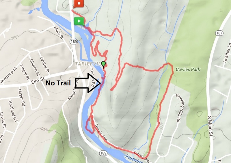
Cowles Park to Tariffville Gorge - East Granby, CT

Date Hiked: Tuesday, May 29, 2018
Estimated distance:  3.41 miles
Weather: 75°F, sunny and a bit humid
Resources: Cowles Park to Tariffville Gorge
Highlights of the trip:  Snake, view from the overlook, river
Progress toward NET Hike 50 Challenge: 10.5/50 miles completed

Hiked today with a couple of others from Cowles Park on Route 187 in East Granby, up to the lookout on the Metacomet Trail over Tariffville Gorge, down to the river, and back through Cowles Park to our cars.


As we were hiking along the ridge, before we got to the overlook, we came across a fairly large black snake.  He did not seem keen to move, so one of the others tried to gently move him along with her hiking pole.  He took exception to that at reared up and hissed.  It was a little nerve wracking even though I was pretty sure it was not a poisonous snake.  He eventually got fed up with us and moved off the trail.  Did I think to get my camera out while this was going on?  No.  Drat.  No snake pictures.


We got a great view from the overlook up and down the river and out across to the same Barndoor Hills we saw during last week's hike at Rattlesnake Mountain in Farmington.


Barndoor Hills in Granby are the two little humps in the middle of the picture.
The trail down to the river was much better marked than I remember it.  We came out on Tunxis Avenue not far from the powerline cut and then walked back up the road so that we could see the water flowing through the gorge.  There is a nice little sandy beach area that allows a good view of the river.  I believe you are advised against swimming there, though.  It would not be safe.


We walked back down the road and followed the trail between two homes back into Cowles Park.  Really, a nice little hike with the hard part over early and a reward of nice views.

If you go, I recommend looking at the map I drew in the post linked at the very top of the page, or getting an app that shows all the various trails in Cowles Park.  There are a lot of criss-crossing mountain bike trails and it could be confusing.  You want to stick to the yellow trail which goes north and then turns south.  When you get to a bench, you will head west on a trail out of Cowles Park, across the power line cut and up to the ridge.  Follow the blue blazes south to the overlook and then continue south on faded blue blazes down to the road.  A sign indicating the Orange Trail back into Cowles Park is on a post between two homes.  Follow that back to the bench at the yellow trail and back to your car.

Enjoy!


Friday, June 30, 2017

Connecticut Hiking Trails by Town - East Granby

CT > Hartford County > East Granby

Metacomet Trail

Looking west to Manitook Mountain from Metacomet Ridge in East Granby.

The Metacomet Trail (part of the New England Trail) passes through East Granby and can be broken up into several sections.

CFPA Interactive Map
CT NET: Section 19 (Tariffville to Route 20)
CT NET: Section 20 (Route 20 to Phelps Road)
Along the New England Trail (11 Oct 2012) - Tariffville Gorge north to Hatchet Hill Road
Along the New England Trail (16 Oct 2012) - Hatchet Hill north to Route 20
Along the New England Trail (18 Oct 2012) - Route 20 north to Suffield line
Hartford Courant Article (19 Jan 2012) by Peter Marteka (Rte 20 north to Peak Mountain Overlook)
Granwood Explores (15 Oct 2016) (Phelps Road south to Rte 20)

Included in the following books:
Connecticut Walk Book (20th Edition) by Connecticut Forest & Park Association
Short Nature Walks in Connecticut (6th Edition) by Eugene Keyarts
50 Hikes in Connecticut (4th Edition) by David, Gerry, and Sue Hardy
Best Hikes with Children in Connecticut, Massachusetts, and Rhode Island by Cynthia C. Lewis and Thomas J. Lewis


Cowles Park

Farmington Valley Homeschoolers (19 May 2012) with hand-drawn map
Google Map of trails and how they connect to Metacomet
Hartford Courant Article (9 Jan 2015) by Peter Marteka


Other Information

East Granby Land Trust (map of all open space properties in town), no trail maps
EGLT Facebook
Newgate Wildlife Management Area - This area is owned by the state and does have a trail, though I am not sure how well it is maintained.  The only reference I can find that has a map is in the book Short Nature Walks in Connecticut by Eugene Keyarts.

Friday, May 5, 2017

Wildflower Walk with East Granby Land Trust


I was afraid the Wildflower Walk with the East Granby Land Trust might be canceled due to rain, but we lucked out.  I met the group in the East Granby Senior Center parking lot.  We started off by walking behind the Center and over toward the elementary school.  There is a little path there and a bridge over the wet areas.


Wood Anemone (Anemone quinquefolia)

Marsh Marigold (Caltha palustris)

Some kind of grass - no idea.  Pretty though.

Canada goose and beaver lodge at pond near senior center.

After spending a few minutes in this area, we headed over to the Metacomet Trail on Route 189 north of Tarrifville.


Persicaria without flowers.

Violet of some kind.

Spring Beauty (Claytonia viginica)

Trout Lily (Erythronium americanum)

Bloodroot (Sanguinaria canadensis)

Jack-in-the-pulpit (Arisaema triphyllum)

Toothwort? Although, I don't remember that name coming up.

Purple Trillium (Trillium erectum)

A look at the Farmington River as it flows through Tarrifville Gorge.

This was a nice, informative hike.  Now, I just have to try and remember what I learned!

Thanks, East Granby Land Trust!


Wednesday, October 26, 2016

Hike #50: Peak Mountain (Metacomet Trail) - Suffield/East Granby

Date Hiked: Saturday, October 15, 2016
Estimated distance:  5.2 miles (based on CF&PA Walk Book)
Weather: 75°F, sunny
Resources:  CF&PA Walk Book West, CT NET: Section 20
Highlights of the trip:  fall colors, views, fun group of people to hike with
Progress toward 2016 hiking goals:  50/52 hikes; 191.35/250 miles; 31.37/25 miles on Tunxis Trail


My husband and I have been attending the Our Night Sky video/discussion series put on by the East Granby Land Trust.  We have really enjoyed it and have met some very nice people.  They invited us to join them on their next hike, and I took them up on their offer.

The plan was to hike the part of the Metacomet Trail that runs from Phelps Road in Suffield, south to the corner of Route 20 and Newgate Road in East Granby.  We met at the East Granby Community Center and carpooled to our starting point in Suffield.  Cars had already been left at the finish in East Granby.


GPS Route from the MapMyHike app using OpenStreetMap.


I thought I had turned my MapMyHike app on before we started, but it didn't register and we were about 3/4 of a mile in before I realized it (that's why I am using the mileage listed in the Walk Book).

Whenever I think about hiking along this section of the trail, I think of an initial climb to gain the ridge and then level trail until the climb down at the end.  That is not really what happens (which you can see by looking at the red elevation line at the bottom of the map above), but the trail is still not that difficult.  The most challenging part is at the start/end in East Granby.  However, when you have a nice group of people to talk with along the way, you barely notice when you are climbing.

Not long after we started the hike, we came to an old chimney on the east side of the trail.  There was a bench nearby (I think there used to be more).  I don't know if this was part of an old cabin or was built as a free-standing structure.  I tried to do a little research, but did not come up with anything.


As we hiked along, there were some great westerly views of Manitook Mountain in Granby. In the picture below, you can see the cliff that is located near the bike trail that goes by the other end of Phelps Road.


We came to several overlooks on our way south.  They are difficult to see in the picture below, but the Barndoor Hills are visible just below the horizon in the middle of the photo.


And while the views may be why most people take this hike, there are plenty of other interesting things to see along the way.  We had some great discussions about various trees - telling white oak, from red, and the different types of white and red oak.  Did you know that black oak is a type of red oak?  Or that there is something called chestnut oak (part of the white oak group)?  We were also on the lookout for witch hazel.  I believe we found it, but with no flowers, there was some discussion.  We also saw quite a few mushrooms, including the Sulphur Shelf, that I think is so cool.

The rocks that make up the ridge are really interesting.  I think we take them for granted when we are standing on them looking out at the spectacular view.  In a couple of places, rocks jut up along the trail, and then you can really get a sense of how amazing they are.  These are the result of volcanic and then earthquake activity.  


Traprock

This was truly a spectacular day to hike.  The air was crisp.  The sky was sunny.  And the leaves on the trees were really amazing.


Our final viewpoint was at Peak (aka Copper) Mountain.  From here, you can look south along the ridge and see Talcott Mountain and the Heublein Tower in the distance.

Talcott Mountain in the distance.

Thank you to the folks of the East Granby Land Trust for inviting me to join them.  I had a great time and look forward to future hikes together.


Tuesday, March 29, 2016

Hike #17: Tariffville Gorge (Metacomet & Cowles Park) - East Granby, CT

Date Hiked:  Saturday, March 26, 2016
Estimated distance round-trip: 3.31 miles
Weather: 40°F, cloudy
Resources: CFPA Interactive Trail Map, Along the New England Trail, FVHH May 2012, FVHH Oct 2012
Highlights of the trip: Blazing a trail (not), river views
Progress toward 2016 hiking goals:  17/52 hikes; 57.22/250 miles; 8/25 miles on Tunxis Trail


My siblings, who were down from New Hampshire for Easter, joined me on my hike this weekend. 

I decided to take them over to Tariffville Gorge.  I have done this hike several times before, starting in Cowles Park in East Granby and climbing up to the Metacomet and the lookout over the gorge.  From the lookout, I have always had to bushwhack my way down to Tunxis Avenue to take the orange trail back to Cowles Park completing the loop.  It just seems to me that there must be a trail that connects the Metacomet to Tunxis Avenue. 


We chose to approach the trail from a different direction.  We parked at the Metcaomet Trail sign on 189 in Tariffville and headed east.  Where the Metacomet started to head away from the river, we left the blue-blazed trail and started following these rather serpentine bike trails.  Eventually, we headed down toward the river looking for the trail I thought must be there.

I was wrong.  There is no trail along the river.

But, we didn't let that stop us.  We continued on, hugging the crumbling, trap rock sides of the gorge until we reached the white trail, which leads to Tunxis Avenue.  If anyone in the houses across the river was watching, I am sure they were thinking we were a bunch of idiots.  I like to think of us as adventurers.  It really wasn't that bad, but I wouldn't recommend doing it.


A shelter in the area of the bike trails.

My sister, sister-in-law, and brother at the start of scramble along the river.

The white trail starts at the gap in the trees in the distance almost directly above the rock in the river in the foreground.

Looking back at the way we came.

We took the white trail to Tunxis Avenue and spent a little time walking along the river.  The water was really rushing today.

Old bridge abutment at the end of Tunxis Ave.  Bridge was washed away in flood of 1955.


We walked down Tunxis Avenue until we picked up the Orange Trail into Cowles Park.  From there, we crossed the power lines and climbed up to the lookout on the Metacomet.  In the distance, at the bend in the river, we could see a group of kayakers.  I think they may have been in a class because they formed into a circle and seemed to stay in one area for awhile.
 

We followed the Metacomet Trail down toward our car.  Along the way we saw someone on a dirt bike.  They weren't on the blue-blazed trail, but based upon tire tracks we found, they had been on it in a few places.  We also passed a couple of mountain bikers.  The trails out here are pretty extensive and look like they could be a lot of fun.

All around, a good hike.  I am now pretty sure there is no good way to complete the loop to Tunxis Avenue, but would recommend just bushwhacking down from the lookout, going south.  See the map from Along the New England Trail.

Sunday, May 10, 2015

East Granby/Suffield - Metacomet Trail

Finally! 

I have finally hiked the section of the Metacomet Trail in East Granby and Suffield from end to end.  (See CT NET: Section 20)  It seems a minor accomplishment.  It is only about 5 miles long, but I was able to achieve something I hadn't before - find the trail register.  I have hiked part way in from the East Granby end and part way in from the Suffield end, but I never saw the trail register that was supposed to be there.  I think I must have missed a small section of the middle of the trail. 


I hiked with my friend, D, and we left one car at the junction of Phelps Road and Route 168 in Suffield.  Then we drove around to the parking on the corner of Newgate Road and Route 20 in East Granby.

There is an initial ascent that is fairly steep, but then things level out for awhile.  If you check out the link above, it indicates numbers of +999 feet/-1007 feet.  I can only assume that that is the cumulative elevation gain and loss over the entire trail section.  My phone indicated that the lowest elevation was 388 feet and the highest was 815 feet.  In general, once you get up on the ridge, there is not a lot of change in elevation except for the ravine between the two peaks, Peak/Copper Mountain and West Suffield Mountain.  (The CT Walk Book gives elevations of the two peaks as 672 and 691 feet, respectively).

Heading up from Route 20, we soon spotted some pretty little violets.  Based on information from the Connecticut Botanical Society website, I am guessing they are birdfoot violets.

Birdfoot Violet?

We also saw a lot of Wild Red Columbine.   Really pretty and they stand out from the browns and greys of the leaves and rocks.

Wild Red Columbine


There are several lookouts to the west along the way (not to the east as indicated by the Walk Book).  The first overlook is quite expansive and gives a great look at the valley and down the ridge line toward Talcott Mountain and the Heublein Tower.  Unfortunately, it was pretty hazy, so our views were limited.  At around the 1.5 mile mark, there is a view of Old Newgate Prison.  Still closed for renovations with no opening date in sight as of this writing.

Old Newgate Prison on far side of road.
The basalt formations along the ridge are really interesting.

Basalt spire.
At about the 4.0 mile mark, there is a great view of flat-topped Manituck Mountain.

Manituck Mountain
The trail register is near one of the viewpoints (can't remember which one).  We nearly missed it because as we came back down from the viewpoint, it was behind us.  One of the people who signed it the day before us was on his way to completing the whole New England Trail.  He was planning on finishing at Mount Monadnock in New Hampshire (which isn't technically on the NET - yet).  I like the idea of setting a goal like this.  The Appalachian Trail is beyond me, but perhaps the NET is achievable.


Friday, October 26, 2012

Visiting Large Trees

As part of our tree study for the month of October, I thought it would be fun to visit some of the large trees nearby. 

On Columbus Day, the family took a hike at Bartholomew's Cobble in Sheffield, MA.  There are two notable trees here.  One, is a huge cottonwood that is hollow at the bottom.  I have read that this is the second largest cottonwood in Massachusetts.  (I found a website that indicated the largest is in Pittsfield, MA.)

B inside the cottonwood.  The record is 12 people.

The other tree that I saw, that the guys completely missed as they hiked on ahead, was a large tulip poplar.  I like tulip trees because of the beautiful flower they have in the spring and the interesting shape of their leaf.

Tulip Tree - October 2012


Tulip Tree flower and leaves - June 2009


Largest Tree in CT
A little closer to home, we visited the locally famous Pinchot Sycamore in Simsbury, CT.  Named for Gifford Pinchot, the first head of the US Forest Service, this tree is the largest tree in the state.

October 2012


More information on the Pinchot Sycamore:
CT Museum Quest
Wikipedia


Coolest Tree in CT
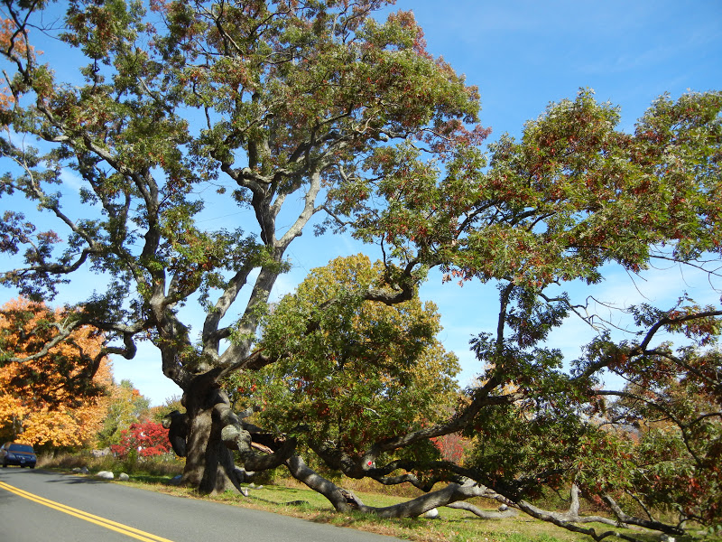
A little reluctantly, we made a visit to the Dewey-Granby Oak.  The Granby Oak is a white oak and is believed to be the oldest oak tree in the state (and possibly the nation) at between 400 to 500 years old.  Last October, Storm Alfred dumped a foot of snow on the area.  Most trees still had their leaves, which resulted in widespread devastation (and eight days without power for much of the state).  The Granby Oak was not spared and some of its huge limbs had to be removed and others were cabled up in the hopes of saving the tree.  I had driven by the oak in the month after the storm and was saddened to see how much damage it had suffered.  On this visit, we got out and walked around the tree.  I was relieved to see that the tree actually looks pretty good.  Though Storm Alfred may ultimately be linked with the death of the tree, it looks like it will be with us for the near future.

October 2012


Information on the Granby Oak:
Salmon Brook Historical Society
CTMuseum Quest  - At the bottom of Steve's post is a picture of what the tree looked like shortly after the storm.  It was crushing to see the great tree in this condition.  This tree is a huge part of Granby (it is on the town seal).  After going back this fall, nearly a year after the storm, I feel much better about its chances to live a little longer.
Granby Land Trust


National Champion Black Oak
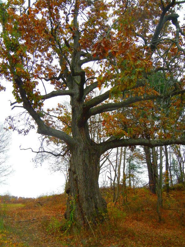
And finally, we paid a visit to the national champion black oak in East Granby.  It is certainly large, but I would never have figured it for a national champion.


More about the National Champion Black Oak:
Connecticut's Notable Trees
CTMuseum Quest - Watch the first minute or so of the video Steve has linked to at the top of his post.  It is a video someone took during and after last year's October snowstorm.  You will get a real sense of what it was like sitting in the dark listening to trees and branches fall all around you.


I just love trees, especially really old, big trees.  This month's Outdoor Hour Challenge at the Handbook of Nature Study blog was a great reminder to get out and enjoy them.