Showing posts with label Tariffville. Show all posts

Monday, January 14, 2019

Metacomet Trail - Tariffville, CT


Date Hiked: Saturday, January 12, 2019
Estimated distance:  2.6 miles
Weather: 22°F, partly cloudy
Resources: OpenStreetMap, New England Trail- CT Section 18
Highlights of the trip:  fun group of people, nice views


This hike was arranged by the Simsbury Land Trust.   We had a good group of people, maybe as many as 20, though I didn't do a head count.  We parked on Church Street Extension in Tariffville and took the Metacomet Trail up Laurel Hill and past the ruins of the Bartlett Tower.  We followed the Metacomet Trail to the cell tower and looped back to the starting point passing a couple of power line cuts.  There is current work going on as they replace the wooden poles with metal ones.


Bartlett tower.
According to our leader, Bartlett Tower used to have a dance hall.  This article at Connecticut Explored gives a more detailed description.


My artsy view of Bartlett Tower.

Looking west.

These type of chimney's dot the Metacomet.

View of the Barndoor Hills in Granby.


Tuesday, May 29, 2018

Cowles Park to Tariffville Gorge - East Granby, CT

Date Hiked: Tuesday, May 29, 2018
Estimated distance:  3.41 miles
Weather: 75°F, sunny and a bit humid
Resources: Cowles Park to Tariffville Gorge
Highlights of the trip:  Snake, view from the overlook, river
Progress toward NET Hike 50 Challenge: 10.5/50 miles completed

Hiked today with a couple of others from Cowles Park on Route 187 in East Granby, up to the lookout on the Metacomet Trail over Tariffville Gorge, down to the river, and back through Cowles Park to our cars.


As we were hiking along the ridge, before we got to the overlook, we came across a fairly large black snake.  He did not seem keen to move, so one of the others tried to gently move him along with her hiking pole.  He took exception to that at reared up and hissed.  It was a little nerve wracking even though I was pretty sure it was not a poisonous snake.  He eventually got fed up with us and moved off the trail.  Did I think to get my camera out while this was going on?  No.  Drat.  No snake pictures.


We got a great view from the overlook up and down the river and out across to the same Barndoor Hills we saw during last week's hike at Rattlesnake Mountain in Farmington.


Barndoor Hills in Granby are the two little humps in the middle of the picture.
The trail down to the river was much better marked than I remember it.  We came out on Tunxis Avenue not far from the powerline cut and then walked back up the road so that we could see the water flowing through the gorge.  There is a nice little sandy beach area that allows a good view of the river.  I believe you are advised against swimming there, though.  It would not be safe.


We walked back down the road and followed the trail between two homes back into Cowles Park.  Really, a nice little hike with the hard part over early and a reward of nice views.

If you go, I recommend looking at the map I drew in the post linked at the very top of the page, or getting an app that shows all the various trails in Cowles Park.  There are a lot of criss-crossing mountain bike trails and it could be confusing.  You want to stick to the yellow trail which goes north and then turns south.  When you get to a bench, you will head west on a trail out of Cowles Park, across the power line cut and up to the ridge.  Follow the blue blazes south to the overlook and then continue south on faded blue blazes down to the road.  A sign indicating the Orange Trail back into Cowles Park is on a post between two homes.  Follow that back to the bench at the yellow trail and back to your car.

Enjoy!


Tuesday, March 29, 2016

Hike #17: Tariffville Gorge (Metacomet & Cowles Park) - East Granby, CT

Date Hiked:  Saturday, March 26, 2016
Estimated distance round-trip: 3.31 miles
Weather: 40°F, cloudy
Resources: CFPA Interactive Trail Map, Along the New England Trail, FVHH May 2012, FVHH Oct 2012
Highlights of the trip: Blazing a trail (not), river views
Progress toward 2016 hiking goals:  17/52 hikes; 57.22/250 miles; 8/25 miles on Tunxis Trail


My siblings, who were down from New Hampshire for Easter, joined me on my hike this weekend. 

I decided to take them over to Tariffville Gorge.  I have done this hike several times before, starting in Cowles Park in East Granby and climbing up to the Metacomet and the lookout over the gorge.  From the lookout, I have always had to bushwhack my way down to Tunxis Avenue to take the orange trail back to Cowles Park completing the loop.  It just seems to me that there must be a trail that connects the Metacomet to Tunxis Avenue. 


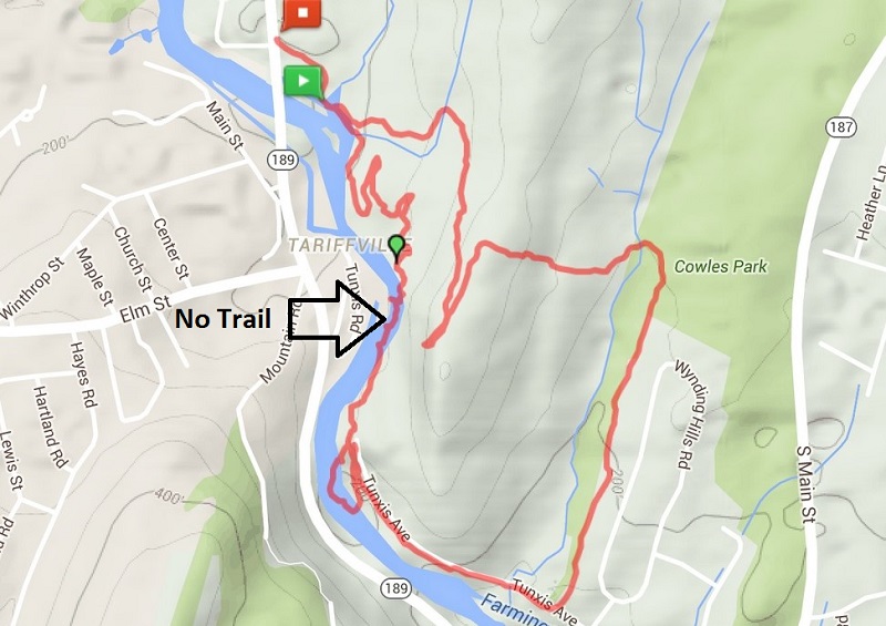
We chose to approach the trail from a different direction.  We parked at the Metcaomet Trail sign on 189 in Tariffville and headed east.  Where the Metacomet started to head away from the river, we left the blue-blazed trail and started following these rather serpentine bike trails.  Eventually, we headed down toward the river looking for the trail I thought must be there.

I was wrong.  There is no trail along the river.

But, we didn't let that stop us.  We continued on, hugging the crumbling, trap rock sides of the gorge until we reached the white trail, which leads to Tunxis Avenue.  If anyone in the houses across the river was watching, I am sure they were thinking we were a bunch of idiots.  I like to think of us as adventurers.  It really wasn't that bad, but I wouldn't recommend doing it.


A shelter in the area of the bike trails.

My sister, sister-in-law, and brother at the start of scramble along the river.

The white trail starts at the gap in the trees in the distance almost directly above the rock in the river in the foreground.

Looking back at the way we came.

We took the white trail to Tunxis Avenue and spent a little time walking along the river.  The water was really rushing today.

Old bridge abutment at the end of Tunxis Ave.  Bridge was washed away in flood of 1955.


We walked down Tunxis Avenue until we picked up the Orange Trail into Cowles Park.  From there, we crossed the power lines and climbed up to the lookout on the Metacomet.  In the distance, at the bend in the river, we could see a group of kayakers.  I think they may have been in a class because they formed into a circle and seemed to stay in one area for awhile.
 

We followed the Metacomet Trail down toward our car.  Along the way we saw someone on a dirt bike.  They weren't on the blue-blazed trail, but based upon tire tracks we found, they had been on it in a few places.  We also passed a couple of mountain bikers.  The trails out here are pretty extensive and look like they could be a lot of fun.

All around, a good hike.  I am now pretty sure there is no good way to complete the loop to Tunxis Avenue, but would recommend just bushwhacking down from the lookout, going south.  See the map from Along the New England Trail.