An update at the end of the first quarter.
1. Take 52 hikes.
17/52 hikes. One quarter of 52 is 13, so I am ahead of schedule.
2. Hike for 250 miles.
57.22/250 miles. To be on target, I should have completed 62.5 miles in the first quarter. I'm not too far off the mark, but I need to do a little bit more.
3. Hike at least 25 miles of the Tunxis Trail
8/25 miles. One quarter of 25 is 6.25, so a little ahead of schedule here.
For the remainder of the list, I just need to pick out some dates and get them on the calendar. Bash-Bish and the other Massachusetts park might be good to do when my Tunxis Trail partner can't join me.
4. Visit Bash Bish Falls (Massachusetts)
5. Hike Mount Monadnock (New Hampshire)
6. Visit a "new-to-me" state park or forest in Massachusetts (Bash Bish does not count).
7. Hike on the Appalachian Trail
Thursday, March 31, 2016
Tuesday, March 29, 2016
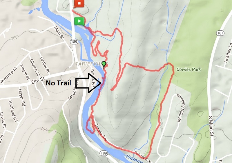
Hike #17: Tariffville Gorge (Metacomet & Cowles Park) - East Granby, CT
Date Hiked: Saturday, March 26, 2016
Estimated distance round-trip: 3.31 miles
Weather: 40°F, cloudy
Resources: CFPA Interactive Trail Map, Along the New England Trail, FVHH May 2012, FVHH Oct 2012
Highlights of the trip: Blazing a trail (not), river views
Progress toward 2016 hiking goals: 17/52 hikes; 57.22/250 miles; 8/25 miles on Tunxis Trail
My siblings, who were down from New Hampshire for Easter, joined me on my hike this weekend.
I decided to take them over to Tariffville Gorge. I have done this hike several times before, starting in Cowles Park in East Granby and climbing up to the Metacomet and the lookout over the gorge. From the lookout, I have always had to bushwhack my way down to Tunxis Avenue to take the orange trail back to Cowles Park completing the loop. It just seems to me that there must be a trail that connects the Metacomet to Tunxis Avenue.

We chose to approach the trail from a different direction. We parked at the Metcaomet Trail sign on 189 in Tariffville and headed east. Where the Metacomet started to head away from the river, we left the blue-blazed trail and started following these rather serpentine bike trails. Eventually, we headed down toward the river looking for the trail I thought must be there.
I was wrong. There is no trail along the river.
But, we didn't let that stop us. We continued on, hugging the crumbling, trap rock sides of the gorge until we reached the white trail, which leads to Tunxis Avenue. If anyone in the houses across the river was watching, I am sure they were thinking we were a bunch of idiots. I like to think of us as adventurers. It really wasn't that bad, but I wouldn't recommend doing it.

We took the white trail to Tunxis Avenue and spent a little time walking along the river. The water was really rushing today.


We walked down Tunxis Avenue until we picked up the Orange Trail into Cowles Park. From there, we crossed the power lines and climbed up to the lookout on the Metacomet. In the distance, at the bend in the river, we could see a group of kayakers. I think they may have been in a class because they formed into a circle and seemed to stay in one area for awhile.

Estimated distance round-trip: 3.31 miles
Weather: 40°F, cloudy
Resources: CFPA Interactive Trail Map, Along the New England Trail, FVHH May 2012, FVHH Oct 2012
Highlights of the trip: Blazing a trail (not), river views
Progress toward 2016 hiking goals: 17/52 hikes; 57.22/250 miles; 8/25 miles on Tunxis Trail
My siblings, who were down from New Hampshire for Easter, joined me on my hike this weekend.
I decided to take them over to Tariffville Gorge. I have done this hike several times before, starting in Cowles Park in East Granby and climbing up to the Metacomet and the lookout over the gorge. From the lookout, I have always had to bushwhack my way down to Tunxis Avenue to take the orange trail back to Cowles Park completing the loop. It just seems to me that there must be a trail that connects the Metacomet to Tunxis Avenue.

We chose to approach the trail from a different direction. We parked at the Metcaomet Trail sign on 189 in Tariffville and headed east. Where the Metacomet started to head away from the river, we left the blue-blazed trail and started following these rather serpentine bike trails. Eventually, we headed down toward the river looking for the trail I thought must be there.
I was wrong. There is no trail along the river.
But, we didn't let that stop us. We continued on, hugging the crumbling, trap rock sides of the gorge until we reached the white trail, which leads to Tunxis Avenue. If anyone in the houses across the river was watching, I am sure they were thinking we were a bunch of idiots. I like to think of us as adventurers. It really wasn't that bad, but I wouldn't recommend doing it.
 |
| A shelter in the area of the bike trails. |
 |
| My sister, sister-in-law, and brother at the start of scramble along the river. |
 |
| The white trail starts at the gap in the trees in the distance almost directly above the rock in the river in the foreground. |
 |
| Looking back at the way we came. |
We took the white trail to Tunxis Avenue and spent a little time walking along the river. The water was really rushing today.
 |
| Old bridge abutment at the end of Tunxis Ave. Bridge was washed away in flood of 1955. |


We walked down Tunxis Avenue until we picked up the Orange Trail into Cowles Park. From there, we crossed the power lines and climbed up to the lookout on the Metacomet. In the distance, at the bend in the river, we could see a group of kayakers. I think they may have been in a class because they formed into a circle and seemed to stay in one area for awhile.

We followed the Metacomet Trail down toward our car. Along the way we saw someone on a dirt bike. They weren't on the blue-blazed trail, but based upon tire tracks we found, they had been on it in a few places. We also passed a couple of mountain bikers. The trails out here are pretty extensive and look like they could be a lot of fun.
All around, a good hike. I am now pretty sure there is no good way to complete the loop to Tunxis Avenue, but would recommend just bushwhacking down from the lookout, going south. See the map from Along the New England Trail.
Monday, March 21, 2016
Hike #16: Tunxis Trail (Roberts Brook) - East Hartland, CT
Date Hiked: Saturday, March 19, 2016
Estimated distance round-trip: 4.61 miles
Weather: 32-40°F, sunny, but cold
Resources: CFPA Interactive Trail Map, Short Nature Walks in CT starting on page 11, CTMQ
Highlights of the trip: Roberts Brook
Progress toward 2016 hiking goals: 16/52 hikes; 53.91/250 miles; 8/25 miles on Tunxis Trail
The friend who hiked with me last weekend on the northernmost part of the Tunxis Trail, joined me again this week for the next section. We left one car at the small parking area at the beginning of Pine Mountain Road and drove up to start our hike where we left one car last week, at the corner of Pine Street and Walnut Hill Road (old Route 20).

I was kicking myself at the start of the hike. I started the MapMyHike app while we were at the car, but then paused it because we were getting stuff out of the back. I forgot to restart it until we were down the trail a little way. It makes it look like we went straight from point A to point B. This only messes up the mileage toward my 250 mile goal. The mileage for the Tunxis Trail is based upon the Connecticut Walk Book.
From the car we headed down old Route 20 and turned south when we got to the blue-blazed Tunxis Trail. I really need to take notes as I hike, because I'm a little confused about Roberts Brook. We hiked across one brook without much water and later came to a brook with much steeper banks, like a ravine. I assumed this was Roberts Brook, because I had looked at topo maps ahead of time and thought Roberts Brook had steep sides. There wasn't much water, so it was a little disappointing that this was supposed to be the highlight of the hike. Somewhere along here (see, I need to take notes), you can see down to the reservoir. It is probably hidden from view once the trees leaf out.
A little farther along the trail, we even came to a trail marker that indicated that Roberts Brook Ravine was in the direction from which we had just come.

Then we came to another stream. This one actually had a lot more water than either of the previous two streams and it would make sense that this was Roberts Brook, regardless of what the sign said.

The trail to the stream was not steep and continued on the other side of the stream. It didn't seem the best place to cross, so we started walking up along the edge of the stream to find some good rocks to use as stepping stones. We thought we found one place, but the bank was a little steeper on the other side. We looked up the stream and, lo and behold, there was a bridge! As far as I can tell, there was no indication on the trail that there was a bridge upstream. I don't think there was a trail that led to it. Did I miss something? It is not mentioned in the Walk Book or any other place I have seen.

We crossed the bridge and took a few more pictures of waterfalls upstream, then bushwhacked our way back to the trail. We came out on a woods road that I thought might be Pine Mountain Road, but looking at my GPS, I could see it was not. We were not doing Pine Mountain today, so I didn't want to pass where our car was parked. There has been logging in the area and there are a couple of spur roads (Roberts Spur Road and Pine Mountain Spur Road) that made things confusing. The GPS was a big help. We came to another road that I was able to confirm was Pine Mountain Road and we walked the mile or so back to the car.

I am not really sure what to make of the signage for Roberts Brook Ravine. My pictures are time-stamped, so I know I came to the sign before getting to what I now believe to be Roberts Brook. I enjoyed this hike, so I may have to go back at some point and take more detailed notes.
I know last week, I ended with "On to Pine Mountain!", but this time I mean it. The next section of the Tunxis will include Pine Mountain and maybe Indian Council Caves.
Estimated distance round-trip: 4.61 miles
Weather: 32-40°F, sunny, but cold
Resources: CFPA Interactive Trail Map, Short Nature Walks in CT starting on page 11, CTMQ
Highlights of the trip: Roberts Brook
Progress toward 2016 hiking goals: 16/52 hikes; 53.91/250 miles; 8/25 miles on Tunxis Trail
The friend who hiked with me last weekend on the northernmost part of the Tunxis Trail, joined me again this week for the next section. We left one car at the small parking area at the beginning of Pine Mountain Road and drove up to start our hike where we left one car last week, at the corner of Pine Street and Walnut Hill Road (old Route 20).

I was kicking myself at the start of the hike. I started the MapMyHike app while we were at the car, but then paused it because we were getting stuff out of the back. I forgot to restart it until we were down the trail a little way. It makes it look like we went straight from point A to point B. This only messes up the mileage toward my 250 mile goal. The mileage for the Tunxis Trail is based upon the Connecticut Walk Book.
From the car we headed down old Route 20 and turned south when we got to the blue-blazed Tunxis Trail. I really need to take notes as I hike, because I'm a little confused about Roberts Brook. We hiked across one brook without much water and later came to a brook with much steeper banks, like a ravine. I assumed this was Roberts Brook, because I had looked at topo maps ahead of time and thought Roberts Brook had steep sides. There wasn't much water, so it was a little disappointing that this was supposed to be the highlight of the hike. Somewhere along here (see, I need to take notes), you can see down to the reservoir. It is probably hidden from view once the trees leaf out.
 |
| What I thought was Roberts Brook. |

Then we came to another stream. This one actually had a lot more water than either of the previous two streams and it would make sense that this was Roberts Brook, regardless of what the sign said.

The trail to the stream was not steep and continued on the other side of the stream. It didn't seem the best place to cross, so we started walking up along the edge of the stream to find some good rocks to use as stepping stones. We thought we found one place, but the bank was a little steeper on the other side. We looked up the stream and, lo and behold, there was a bridge! As far as I can tell, there was no indication on the trail that there was a bridge upstream. I don't think there was a trail that led to it. Did I miss something? It is not mentioned in the Walk Book or any other place I have seen.

We crossed the bridge and took a few more pictures of waterfalls upstream, then bushwhacked our way back to the trail. We came out on a woods road that I thought might be Pine Mountain Road, but looking at my GPS, I could see it was not. We were not doing Pine Mountain today, so I didn't want to pass where our car was parked. There has been logging in the area and there are a couple of spur roads (Roberts Spur Road and Pine Mountain Spur Road) that made things confusing. The GPS was a big help. We came to another road that I was able to confirm was Pine Mountain Road and we walked the mile or so back to the car.

I am not really sure what to make of the signage for Roberts Brook Ravine. My pictures are time-stamped, so I know I came to the sign before getting to what I now believe to be Roberts Brook. I enjoyed this hike, so I may have to go back at some point and take more detailed notes.
I know last week, I ended with "On to Pine Mountain!", but this time I mean it. The next section of the Tunxis will include Pine Mountain and maybe Indian Council Caves.
Saturday, March 19, 2016
Hike #15: McLean Game Refuge - Granby, CT
Date Hiked: Wednesday, March 16, 2016
Estimated distance round-trip: 3.51 miles
Weather: 55°F, sunny
Resources: McLean Game Refuge, Trail Map
Highlights of the trip: beautiful almost-spring day
Progress toward 2016 hiking goals: 15/52 hikes; 49.3/250 miles; 4.6/25 miles on Tunxis Trail


Estimated distance round-trip: 3.51 miles
Weather: 55°F, sunny
Resources: McLean Game Refuge, Trail Map
Highlights of the trip: beautiful almost-spring day
Progress toward 2016 hiking goals: 15/52 hikes; 49.3/250 miles; 4.6/25 miles on Tunxis Trail


Tuesday, March 15, 2016
Hike #14: Tunxis Trail (Hurricane Brook) - Hartland, CT
Date Hiked: Saturday, March 12, 2016
Estimated distance round-trip: 5.46 miles
Weather: 60°F, sunny
Resources: CT Forest & Park Association (CFPA) Interactive Trail Map, CTMQ Hikes, Short Nature Walks in CT starting on page 15
Highlights of the trip: driving Pell Road, streams and waterfalls
Progress toward 2016 hiking goals: 14/52 hikes; 45.79/250 miles; 4.6/25 miles on Tunxis Trail
One of my 2016 hiking goals is to hike at least 25 miles of the Tunxis Trail. I have hiked sections before, but I'd like to start fresh. This hike is the first step toward reaching that goal.

Twenty-five miles is certainly a modest goal, but one made slightly more difficult by wanting to round up a hiking partner. I will often hike by myself, but being able to place a car at one end of the trail section and start at the other makes things a lot easier. The northern end of the Tunxis is also pretty remote and a partner is a good idea for safety.
Before venturing out, I did some research using CFPA's CT Walk Book. I wanted to start at the northern end of the trail near the Massachusetts border and hike south to either Route 20 (2.8 miles) or Old Route 20 - Walnut Hill Road extension (4.6 miles). My hiking partner was up for the longer distance, so we left my mom-mobile (minivan, which currently only has seating for two because of the street hockey nets and other equipment loaded in the back) near the gate at the corner of Walnut Hill Road and Pine Street and headed off in her Jeep for the trail head.
According to the Walk Book, there is parking on Pell Road near the trail head. For most of its length, Pell is a dirt road. I had read Steve Wood's account of his mom driving her minivan along this road and figured we could leave the car at the corner of Pell and East Pell Roads. Well...as we drove along, we started to wonder if the minivan would be able to get us back to the Jeep when we were done. The Jeep was doing fine with its high ground clearance, but the van would be another story. We turned on the GPS and noticed that East Pell was a lot shorter than Pell and would take us out to Route 179 (Granville Road). We decided to drive out East Pell just to see how that road was and see if it would be easier for the van. Well, hello! Just a short distance down East Pell, the dirt road turned to pavement and there was a little parking area! That would have been nice to know!
Looking at a screenshot of the Interactive Map from CFPA, you can see that the parking area actually appears in Massachusetts, just north of the trail head on McCarthy Road. Looking at Google Maps, there are houses along this road, so it would probably work. Where we ended up parking (after driving most of the length of Pell Road) was on East Pell Road, I would guess roughly at the edge of the green area on the map below. It was a short walk in to the trail head from there. If you decide to park on McCarthy Road, you need to drive around and not try to go up Pell Road.

Now, on to the hike!
At the trail head, there was a little sign giving mileage amounts to Route 20 and beyond and a trail register. I signed in and we started hiking. Before too long, we came to the CT/MA boundary marker. On the Massachusetts side, there was a large field with a camper in the middle of it.

The trail started to head down hill. It became steeper as we approached a stream with a nice little waterfall. Check out this quadrangle map and see how close the contour lines are. I think this might be the stream referred to as Trailhead Stream in the Walk Book.
There were a couple of brook crossings and in one area we could see the DEEP lean-to. I had hiked in to this point from the other direction in 2012, and the lean-to was in pretty rough shape. We did not go over to look at it today, but I think it may have undergone renovation because it had a new metal roof on it.
Hurricane Brook was probably the low elevation on the trail. We then started climbing and made our way to the top of Trillium Hill (no view). It is here on the interactive map (see above), that there is a trail notice indicating that the trail is closed for timber operations. I did not know this before we started hiking, but there was nothing going on today as we hiked through there.
Unfortunately, I think the Trail Notices section of the CFPA website needs some work. When I use the interactive map and see that there is a trail notice, there is a link for more information. That takes me to a general page where I can click the link for Trail Notices. The notice for this section of trail is not even listed. There are listings for other trail closures, one dated from 2012. Is the trail still closed in that location? Maybe, but now I am not sure that I can trust this listing.
We came out to Route 20 and turned left, walking just a short distance up the road and crossing where we saw the CFPA tags on the trees. The trail on this side of Route 20 was a lot easier than the other side. We came to what I thought might be Balance Rock Road (mentioned in the Walk Book, but not included on their map!) I was using the MapMyHike app, so I pulled out my phone to see if I could tell where we were and sure enough, it had us standing on Balance Rock Road.
Before long, we came to a nice little stream (Morey's Brook?) with several areas of little waterfalls. There were signs here indicating an alternative trail for high water, which takes you over a bridge. We opted to stick to the main trail and we crossed the brook just below the bridge.


We hiked a little farther and came out on old Route 20 (extension of Walnut Hill Road). The road here is beat-up asphalt and there was an SUV driving toward us (we had seen that the gate was open when we dropped off the van). I was hoping it was a DEEP employee dropping off a bear (see Steve Wood's description of what he saw), but no, it was just a couple out exploring. They soon turned around and came back. We took old Route 20 back to the van and drove up Route 179 (NOT Pell Road) and picked up the Jeep.
This was an excellent hike! It feels really remote and the waterfalls, while not showstoppers, are very nice. The trails were very well blazed and extra information was written on the blazes in a couple of areas (for high water by-passes).
I used the Walk Book when planning this hike and I would make a couple of recommendations. I would suggest looking at the interactive map on the CFPA website. It is probably more up to date and you can also see elevations listed on the contour lines. For some reason, the maps in the Walk Book include the contour lines, but no way of determining the actual elevation. Also, Balance Rock Road is not shown on the printed map, but you will see it online.
On to Pine Mountain!
Elevation Data:
I'm still trying to figure out the elevation graphic on MapMyHike. As I mentioned somewhere else, the graph does not match the numbers printed below it, but I think that is because two different methods are being used. One way probably uses GPS info and the other maybe uses some kind of underlying terrain map of the area. I really have no idea. What I had not paid attention to before was the elevation gain. I assumed it was the difference between the max and min, but it is not. Perhaps it is cumulative elevation gain?

My guess is the low point on the graph is Hurricane Brook and the high point to the right is Trillium Hill. After Trillium Hill you make your way down to Route 20. Everything to the right is the trail between Route 20 and old Route 20. You can see it was a lot easier than the first part of the hike.
Estimated distance round-trip: 5.46 miles
Weather: 60°F, sunny
Resources: CT Forest & Park Association (CFPA) Interactive Trail Map, CTMQ Hikes, Short Nature Walks in CT starting on page 15
Highlights of the trip: driving Pell Road, streams and waterfalls
Progress toward 2016 hiking goals: 14/52 hikes; 45.79/250 miles; 4.6/25 miles on Tunxis Trail
One of my 2016 hiking goals is to hike at least 25 miles of the Tunxis Trail. I have hiked sections before, but I'd like to start fresh. This hike is the first step toward reaching that goal.

Twenty-five miles is certainly a modest goal, but one made slightly more difficult by wanting to round up a hiking partner. I will often hike by myself, but being able to place a car at one end of the trail section and start at the other makes things a lot easier. The northern end of the Tunxis is also pretty remote and a partner is a good idea for safety.
Before venturing out, I did some research using CFPA's CT Walk Book. I wanted to start at the northern end of the trail near the Massachusetts border and hike south to either Route 20 (2.8 miles) or Old Route 20 - Walnut Hill Road extension (4.6 miles). My hiking partner was up for the longer distance, so we left my mom-mobile (minivan, which currently only has seating for two because of the street hockey nets and other equipment loaded in the back) near the gate at the corner of Walnut Hill Road and Pine Street and headed off in her Jeep for the trail head.
According to the Walk Book, there is parking on Pell Road near the trail head. For most of its length, Pell is a dirt road. I had read Steve Wood's account of his mom driving her minivan along this road and figured we could leave the car at the corner of Pell and East Pell Roads. Well...as we drove along, we started to wonder if the minivan would be able to get us back to the Jeep when we were done. The Jeep was doing fine with its high ground clearance, but the van would be another story. We turned on the GPS and noticed that East Pell was a lot shorter than Pell and would take us out to Route 179 (Granville Road). We decided to drive out East Pell just to see how that road was and see if it would be easier for the van. Well, hello! Just a short distance down East Pell, the dirt road turned to pavement and there was a little parking area! That would have been nice to know!
Looking at a screenshot of the Interactive Map from CFPA, you can see that the parking area actually appears in Massachusetts, just north of the trail head on McCarthy Road. Looking at Google Maps, there are houses along this road, so it would probably work. Where we ended up parking (after driving most of the length of Pell Road) was on East Pell Road, I would guess roughly at the edge of the green area on the map below. It was a short walk in to the trail head from there. If you decide to park on McCarthy Road, you need to drive around and not try to go up Pell Road.

Now, on to the hike!
At the trail head, there was a little sign giving mileage amounts to Route 20 and beyond and a trail register. I signed in and we started hiking. Before too long, we came to the CT/MA boundary marker. On the Massachusetts side, there was a large field with a camper in the middle of it.

The trail started to head down hill. It became steeper as we approached a stream with a nice little waterfall. Check out this quadrangle map and see how close the contour lines are. I think this might be the stream referred to as Trailhead Stream in the Walk Book.
 |
| Huge pieces of quartz. |
 |
| Pretty little waterfall. You can judge how steep the trail was here. |
 |
| Hurricane Brook |
 |
| Hurricane Brook waterfall. Bridge for Hurricane Brook Road is on the right near the top. |
Unfortunately, I think the Trail Notices section of the CFPA website needs some work. When I use the interactive map and see that there is a trail notice, there is a link for more information. That takes me to a general page where I can click the link for Trail Notices. The notice for this section of trail is not even listed. There are listings for other trail closures, one dated from 2012. Is the trail still closed in that location? Maybe, but now I am not sure that I can trust this listing.
We came out to Route 20 and turned left, walking just a short distance up the road and crossing where we saw the CFPA tags on the trees. The trail on this side of Route 20 was a lot easier than the other side. We came to what I thought might be Balance Rock Road (mentioned in the Walk Book, but not included on their map!) I was using the MapMyHike app, so I pulled out my phone to see if I could tell where we were and sure enough, it had us standing on Balance Rock Road.
Before long, we came to a nice little stream (Morey's Brook?) with several areas of little waterfalls. There were signs here indicating an alternative trail for high water, which takes you over a bridge. We opted to stick to the main trail and we crossed the brook just below the bridge.


We hiked a little farther and came out on old Route 20 (extension of Walnut Hill Road). The road here is beat-up asphalt and there was an SUV driving toward us (we had seen that the gate was open when we dropped off the van). I was hoping it was a DEEP employee dropping off a bear (see Steve Wood's description of what he saw), but no, it was just a couple out exploring. They soon turned around and came back. We took old Route 20 back to the van and drove up Route 179 (NOT Pell Road) and picked up the Jeep.
This was an excellent hike! It feels really remote and the waterfalls, while not showstoppers, are very nice. The trails were very well blazed and extra information was written on the blazes in a couple of areas (for high water by-passes).
I used the Walk Book when planning this hike and I would make a couple of recommendations. I would suggest looking at the interactive map on the CFPA website. It is probably more up to date and you can also see elevations listed on the contour lines. For some reason, the maps in the Walk Book include the contour lines, but no way of determining the actual elevation. Also, Balance Rock Road is not shown on the printed map, but you will see it online.
On to Pine Mountain!
Elevation Data:
I'm still trying to figure out the elevation graphic on MapMyHike. As I mentioned somewhere else, the graph does not match the numbers printed below it, but I think that is because two different methods are being used. One way probably uses GPS info and the other maybe uses some kind of underlying terrain map of the area. I really have no idea. What I had not paid attention to before was the elevation gain. I assumed it was the difference between the max and min, but it is not. Perhaps it is cumulative elevation gain?

My guess is the low point on the graph is Hurricane Brook and the high point to the right is Trillium Hill. After Trillium Hill you make your way down to Route 20. Everything to the right is the trail between Route 20 and old Route 20. You can see it was a lot easier than the first part of the hike.
Sunday, March 13, 2016
Hike #13: McLean Game Refuge - Granby, CT
Date Hiked: Wednesday, March 9, 2016
Estimated distance round-trip: 2.23 miles
Weather: 60°F, sunny
Resources: McLean Game Refuge, Trail Map
Highlights of the trip: just a beautiful, sunny day
Progress toward 2016 hiking goals: 13/52 hikes; 40.33/250 miles

Just an absolutely gorgeous day, especially for this early in March. I hiked in the morning and the temperature was probably around 60°F. I believe it got up to around 80°F later in the day. For March 9th! Crazy.
Here are two pictures of Kettle Pond for comparison. The top photo taken today and the bottom taken exactly two months ago on January 9. We've had a bit more rain, so you can see I wasn't able to stand where I took the picture in January.


Subscribe to:
Posts (Atom)