Friday, October 18, 2013

Alexandria, NH - Mount Cardigan

Date Hiked:  Saturday, October 12, 2013
Number in Group: 11
Estimated distance round-trip: 5.9 miles
Weather: 59°F, cloudy, extremely windy at the top
Resources: Mount Cardigan Loop Trail Route, AMC Cardigan Lodge
Highlights of the trip: fun with family, Cathedral Forest Trail, summit in the clouds

Several months ago, I told my sister that for my upcoming "big" birthday, I wanted to return to Mount Cardigan.  Our eighth grade classes had camped and hiked on this mountain, and I thought it would be a fun way to celebrate my birthday.  Well, it seemed like a great idea back in July.  My sister didn't let me forget, and we rounded up the other siblings and their families and went for a hike!

Mount Cardigan, located in the towns of Alexandria and Orange, NH is only 3,155 feet tall, but has spectacular views from its bald summit.  A forest fire in 1855 was so intense that the trees on the summit never grew back.  I read somewhere that Firescrew, the other peak along the trail, was named for the spiraling motion of the fire and smoke that came off it during the fire.

The route we took started at the AMC's Cardigan Lodge.  We did Holt Trail - Cathedral Forest Trail - Clark Trail - Mowglis Trail - Manning Trail - and back to the lodge.

Heading out on the Holt Trail.

Crossing a stream

That's right.  We took the easiest route.

Cathedral Forest Trail.
My brother and I were pulling up the rear.  My husband stopped and waited for us and while he was waiting, eating his GORP, he noticed a bear coming through the woods toward him.  He made noise to let the bear know he was there and it quickly turned around and went the other way.  (Or at least that's what he says.  He has no photographic evidence!  I guess I'll believe him, though.)


The rocks at the top of the mountain were another chance for my son and I to talk about geology and the rock cycle.  The top of Cardigan is composed of plutonic igneous rock.  Essentially, it had been a large underground magma chamber.  Since it was underground, it cooled slowly allowing larger crystals to form.  Also, as it cooled, it contracted leaving cracks that allowed other igneous material to flow in.  (A better explanation can be found here.)

Plutonic igneous rock with large crystals crossed by a vein.
Unfortunately, although the weather at the bottom wasn't bad, we could see that the top was in the clouds.  The weather report at the lodge indicated things were supposed to clear, but they never did.  In fact, the weather at the top was cold and extremely windy.  Thankfully, it was not raining.

Just before we left the cover of the trees, we met another family coming down.  Imagine our surprise when we found it was people we know from our home in Connecticut!

Near the top.

So much for the view.

Heading over to Firescrew.

One of the little ponds/puddles on the summit.
Below the summit of Firescrew, we stopped and had our lunch.  In some ways, the trail down was more difficult than the trail up.  There seemed to be a lot more rocks and roots to deal with.

Big boulder on the trail behind us makes me think of Raiders of the Lost Ark.

Weird round lichen on boulder.

Looking back up the trail at the fall colors.
The hike took around 5 hours.  It certainly would have taken a lot less for many in our group, but they were good eggs and waited up periodically for the old lady.  Even though we didn't get ANY view from the top, I still had a great time.  I would like to do it again, though.

Thanks to my siblings and family members for joining me on my birthday hike.  And a special thanks to my sister for not letting me back out.

Wednesday, October 16, 2013

Kent - Kent Falls and CAMA

I think October may be the best month of the year.  The cooler temperatures and colorful foliage make being outside a real treat.

Today we took a field trip to Kent, CT.  We are studying Earth Science this year and there is a great little museum in Kent that has a top-notch geology display.  We had been to the Connecticut Museum of Mining & Mineral Science several years ago and some of the display cases were still under construction.  I tucked it away in the back of my mind as a place to revisit.

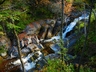
The museum is near Kent Falls State Park and you just can't go by these beautiful cascades without stopping.  As a bonus to our Earth Science study, the park website also had an explanation of the geology.  We read the information before we went and noted the features mentioned as we walked.


Potholes in the marble.

Crumbly marble.


After enjoying our walk at the park, we headed over to the Connecticut Antique Machinery Association (CAMA) of which the Mining Museum is part.

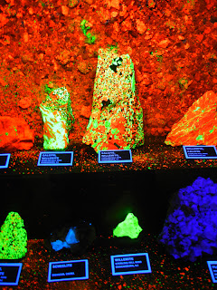
The Mining Museum, in addition to a very impressive collection of minerals, has displays that show: the rock cycle, the formation of igneous and metamorphic rocks, explanations of crystal structure and mineral cleavage, and dioramas of mining and quarrying operations in Connecticut.  There is also a whole room devoted to mining and brick-making.  Really, quite impressive in such a small space and beautifully done.


Fluorescent rocks. 
Pictures can't capture how cool these are.

Mine shaft diorama.

Mining exhibits.  Note the collection of bricks for the floor.


Once we completed our tour of the Mining Museum, we ventured out to some of the other buildings.  Truth be told, this is the part of the trip that had Bill excited.


Tractors, tractors, and more tractors.


Where is Mike Mulligan?

Industrial steam engine
(with Lunkenheimer valves - the company my grandfather worked for).
Our one disappointment was that our usual lunch place was closed for renovation.  We usually go to the deli counter at the general store (with the creaky old wooden floors) in Cornwall Bridge.  Some research shows that it will still be general store when it reopens.  I hope they didn't renovate the charming old floors. 

We drove into Kent and found another place to get lunch.  We ate along the river at Housatonic Meadows State Park (although we did have to retreat to the car when the gnats became too much).

A successful field trip for all involved!


Monday, October 14, 2013

Russell, MA - Noble View

Date Hiked:  Saturday, October 5, 2013
Estimated distance round-trip:  4 miles
Weather: 70°F, cloudy
Resources:  Noble View Outdoor Center
Highlights of the trip: waterfalls, view from the lawn

Noble View, owned since 1931 by the Appalachian Mountain Club, covers over 350 acres and has 17 miles of trails.  Lodging is available if you want to spend more time.  The cottages and campsites are at the top of a hill with tremendous easterly views.

A friend and I met in the parking lot at 9:30 in the morning.  Neither of us had ever hiked at Noble View, but the trail map gave us a lot of choices.  We decided to do a loop starting from the parking lot and going down the Pitcher Brook Trail.  We followed this first to Little Pitcher Falls and then Big Pitcher Falls. 

Little Pitcher Falls

Big Pitcher Falls.

Our plan was to continue on this trail and hook up with the Charcoal Kiln Trail, but not long after Big Pitcher Falls, we lost the trail and ended up doing some bushwhacking.  We eventually crossed the Border Trail around markers 31 & 32.  We followed the Border Trail to the intersection with Laurel Lane and continued down to the Charcoal Kiln Trail.  No worries.

Puffballs.

Green stain fungus.

Off of the Charcoal Kiln Trail are two short spurs to overlooks.  Unfortunately, the trees have grown up enough to obscure any view.  We continued down the trail to the actual location of the Charcoal Kiln.

Charcoal kiln.

From here we had the choice of climbing back up along the Dam Brook Trail or going farther to the Glacial Erratic and up the County Road Trail. Our map indicated trail closures in both directions, but we figured we could bushwhack again if we had to.  We decided to head back up along the brook and connect with Laurel Lane to get back to the top.

Dam Brook.

We were able to follow blazes along the brook, but the trail could definitely use some work.  It appears that there was a washout or something, so perhaps one of the dams let go.  If you read the website, it sounds like the dam had a leak, so it is possible. 

More puffballs.

View looking over Westfield.

We really had a fantastic hike.  The blazing of the trails left a little to be desired and some of the trails could use some work, but all of the numbered markers were in place and were extremely helpful.

We finished our hike around 2 p.m. and we took a few moments to sit on a rock and enjoy the view.  There was a large group of campers that seemed to be having a great time with various activities.  Must have been these guys from Worcester.  Fantastic!

I will definitely be back to try some of the other trails.

Wednesday, October 2, 2013

Torrington - Burr Pond Kayak

The first day of October and it was spectacular!

I went with my son and a friend of mine over to Burr Pond State Park in Torrington.  We put our kayaks in at the boat launch and headed off counter-clockwise around the pond.   It's a great little place to kayak.  There are small islands to maneuver around and big rocks lurking just under the water.  It reminds me of the lakes you would find in Maine.  We saw a few mallards, a turtle, and some Canada geese in the pond, and turkey vultures soaring above.

Painted turtle.

The colors are just starting to show.
I love kayaking at Burr Pond because it feels so remote.  No houses along the shore.  The state park does have a small beach and picnic area, but in the middle of the week, in October, there were only a few people there and it was very quiet.  This has become a favorite place to kayak.

Looking north from the far end of the pond.