Thursday, August 11, 2016

West Branch (aka Hogback) Reservoir - Colebrook, CT

Date Paddled: Tuesday, August 9, 2016
Estimated distance: 3.62 miles (not all paddling, as we got up and climbed up the spillway)
Weather: 81°F, scattered clouds
Resources:  MDC Farmington River, Colebrook Historical Society, Book:  Quiet Water Massachusetts, Connecticut and Rhode Island
Highlights of the trip:  views


My hiking partner and I decided to go for a paddle in our kayaks today.  I had heard about Hogback Reservoir from one of my neighbors and wanted to give it a try.  The weather was perfect - sunny, but not too hot (no swimming allowed).


My friend tried entering the boat launch into her GPS without success, so here are some directions:  From the center of Riverton (facing the General Store), go left/west on Robertsville Road.  This turns into Riverton Road as you enter Colebrook.  Turn right on Eno Hill Road.  Turn right again on Durst Road (sign for road on pillar).  The parking lot for the boat launch is on your left just before the dam.  Although the road over the dam goes all the way across to Hogback Road, I think it is gated.


There was a lot of construction going on and, at first, I was not sure whether we would be able to get to the launching area.  Then we noticed a gap in the silt fence with a driveway that went down to the launch.  You can not launch using a trailer.  We unloaded our kayaks and parked in the upper lot.  There is a port-a-potty available.


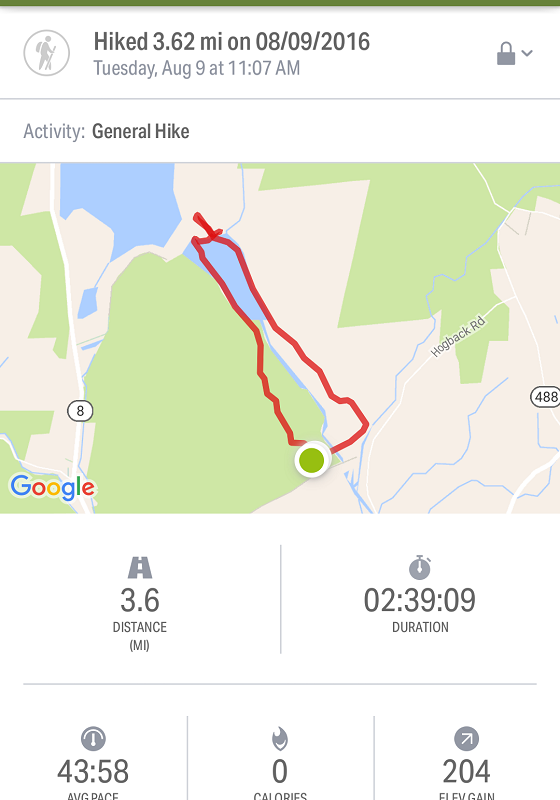
I know, it looks like we paddled over dry land.  For some reason the map doesn't show the full size of the reservoir.  We parked at what used to be called Hogback Dam, but has been renamed Goodwin Dam.  At the other end of the West Branch Reservoir is the Colebrook River Dam with Colebrook River Lake beyond. 

We paddled up the west side of the reservoir.  There were a couple of spots that looked kind of interesting and may have had trails that went down to them.


The only island.  Someone had stacked a rock cairn on it.
We paddled to the northern end where the Colebrook River Dam is located.  My neighbor has said that he climbs to the top and gets great views of both bodies of water.  Does he really climb these rocks?


Not too sure about climbing this.
Instead of climbing the rocks, we went around to the east side that had an area of exposed bedrock (and weeds) and climbed here.

Looking back down the reservoir.

Part way up the hill.


As we climbed, we realized we were not in the place my neighbor had suggested, and were probably in a place that we should not be.  We appeared to be in the spillway for the upper reservoir.  It has been very dry here this summer, so I doubted we were in danger of water coming over the top, and when we got to the top, we found that was true.  We were faced with a field with the water quite a distance away.


Looking across field to Colebrook River Lake from top of spillway.
We paddled back down the reservoir, this time along the eastern shore.  The wind was against us, but by sticking close to the shore, it wasn't too bad.  We could see a bald eagle soaring above.  We approached the spillway with no fear of being sucked over and then paddled back to the boat launch.


Looking back at the Colebrook River Dam.
In front of the parking area, there are tables with nice views of the reservoir.  I'll have to keep this place in mind and maybe come up here this fall for a picnic with some sandwiches made at the Riverton General Store.


One last look from picnic area.


Wednesday, August 3, 2016

Hike #40: White Memorial Foundation - Litchfield, CT

Date Hiked: Wednesday, August 3, 2016
Estimated distance: 6.26 miles
Weather: 70°F, clear and sunny
Resources: White Memorial Foundation Trails
Highlights of the trip:  boardwalk, wildlife
Progress toward 2016 hiking goals:  40/52 hikes; 150.98/250 miles; 31.37/25 miles on Tunxis Trail


I have lived in CT for over 30 years now (good grief!) and had never been to White Memorial Foundation in Litchfield.  My hiking partner and I decided to remedy that today.


Using the book, AMC's Best Day Hikes in Connecticut, and a map printed from the White Memorial Foundation website, I plotted our route.  This was not an easy task.  I, quite literally, needed a magnifying glass to read the minuscule print on the map.  But, I persevered and came up with a plan to hike by Mallard Marsh and around Little Pond.  Our first stop when we got to White Memorial was to stop in the museum and buy a larger scale version of the map for $3.  Now I have it for future reference.


There are lots of criss-crossing trails here and it is easy to get confused (at least we thought so).  Many of the trails are marked with colored symbols like a red triangle, for example.  The map is not directly labeled with the symbol, but with a letter that you then have to look up and find out what the colored symbol is.  It wasn't difficult, just a little annoying because it meant flipping the map from side to side to find the key.


Near Mallard Marsh

Yum.  High bush blueberries in abundance!

We made our way over to Little Pond which is encircled by a boardwalk.  Building that boardwalk was an ambitious project, and we really appreciate the work that went into it and what it requires to maintain.

View from the bridge on the boardwalk.

Looking back on bridge.

Monarch on jewelweed.

Buttonbush

Looking south across the pond.

We returned to the museum area and then took the Lake Trail down to the viewing platform on Bantam Lake.  The Ice House Ruins Trail is also in this area, and we could see the concrete supports from the conveyor that had been in operation during the ice harvesting in the early 20th Century.

North Bay of Bantam Lake and conveyor supports.

Canal used in ice operation.

White Memorial Foundation was well worth the drive.  I feel like we covered a lot of ground, but there are a few more trails that might be worth trying.  A visit in the fall could be spectacular.


Monday, August 1, 2016

Hike #39: GLT's Western Barndoor Preserve - Granby, CT

Date Hiked: Monday, August 1, 2016
Estimated distance: 1.23 miles
Weather: 77°F, mostly cloudy
Resources:  Granby Land Trust's Western Barndoor Hill Preserve Trail Map
Highlights of the trip:  views from the top
Progress toward 2016 hiking goals:  39/52 hikes; 144.72/250 miles; 31.37/25 miles on Tunxis Trail


My son was interested in doing another hike.  With me!  What a nice kid.  So far he has wanted to stick close to home.  I think it is because he does not want to take the time to drive to anything too far away.  Plus, he knows I am a slow hiker, so any hike with me will take awhile.

One of the things he has wanted to do is to hike from our house, through McLean Game Refuge, and up to the top of the Western Barndoor Hill.  The game refuge map, does not show a trail leading to the parking area for the Western Barndoor Hill on Barndoor Hills Road, but I was pretty sure there was a way to get through.  So, my suggestion was that we drive over to Barndoor Hills Road, climb the hill and then he could figure out a way back through the refuge.  He was happy with that plan.

As mentioned above, the parking for the Western Barndoor Hill is located on Barndoor Hills Road, right across from Kettle Pond Lane.  There is room for 2-3 cars at the side of the road.


We walked up Kettle Pond Lane to the clearly marked trail head on the left hand side of the road.  The trail climbs steadily, but it is not difficult.  It loops around the houses on Kettle Pond and you can also see houses on Black Oak Drive.

It was cooler today, but still seemed pretty humid.  We had no trouble working up a sweat on this short hike and my son was lamenting the fact that we forgot to put on bug spray.  I was fortunate to have him along, as he seemed to be the insect magnet.

The area at the top of the hill is quite pleasant.  No real undergrowth, just grass and scattered trees.  Unfortunately, I did not take a picture.  (For pictures of the trail, see Steve Wood's CT Museum Quest website).  The trail leads to an overlook which provides views to the Eastern Barndoor Hill in the game refuge and north to Manitook Mountain and even Mount Tom in Massachusetts.

Eastern Barndoor Hill

Cool old cedar tree.
The other day I had my son show me how to pay for the PeakFinder App and today was my first chance to use it.  I probably should have re-watched the video that shows how it works, but I managed to get what I wanted.  You can compare the two images below.  The large hill in the middle of the picture is nearby Manitook Mountain.  To the left of that, way in the distance, you can see Mount Tom in Holyoke, MA.


The app took some getting used to in that things don't seem totally lined up with the direction your phone is pointing, but it was close enough to use the shape of the mountains to figure things out. 

You can also use PeakFinder on your computer.  I use it in combination with Google Maps.  I drop a pin on my location on a peak to get coordinates.  I type those into Peakfinder and then use the compass to face in the correct direction.  Using Google Maps in 3D is cool, too.  Get to the right location and then use 3D to tip the map and look off into the distance.

My son and I returned to the car where he put on some bug spray and headed off on a trail into the game refuge.  The trail is not on the game refuge map, but he said he came out into the fields between Kettle Pond and Spring Pond and picked up the trail there.  I headed into the center of town and then home and he came in the door not long after me.  So, now he knows he can hike from our door to the Western Barndoor Hill.  Next, he'll have to see if he can make it all the way to Holcomb Farm.