Friday, December 30, 2016

Update: 2016 Hiking Goals

Final year-end update.  Not a total success, but having some goals got me out the door.  Next year I need to be more consistent and persistent.

1.  Take 52 hikes.  
55/52 hikes.  


2.  Hike for 250 miles.
😞
218.25/250 miles.  Close, but no cigar.  I hike fairly regularly with one person, but sometimes she is not available.  I need to find a way to get out when she is not available.

3.  Hike at least 25 miles of the Tunxis Trail
31.37/25 miles.  This goal has been completed.  I feel this was a big accomplishment.  31 miles is pretty small potatoes, but I think it is pretty cool that I hiked from the Massachusetts border to Burlington (in multiple sections).


4.  Visit Bash Bish Falls (Massachusetts)
😞
Kept putting this one off because of the drought.

5.  Hike Mount Monadnock (New Hampshire)
😞
Got scared off of this one by some other people.  I may add it to my 2017 list, but I need to do some other tougher (for me) hikes before I do this one.

6.  Visit a "new-to-me" state park or forest in Massachusetts (Bash Bish does not count).
Hiked the D.A.R. State Forest in Goshen, MA on April 23.


7.  Hike on the Appalachian Trail
Completed on July 20.  Hike #38 - Lion's Head in Salisbury, CT.


Monday, December 26, 2016

Hike #55: McLean Game Refuge, Granby

Date Hiked: Tuesday, December 13, 2016
Estimated distance:  4.6 miles
Weather: 39°F, sunny
Resources: McLean Game Refuge, Map
Highlights of the trip:  snow scenes
Progress toward 2016 hiking goals:  55/52 hikes; 218.25/250 miles; 31.37/25 miles on Tunxis Trail


Today I entered the Refuge from Canton Road and went down the hill to Spring Pond.  It had snowed Sunday and there was still an inch or so on the ground.  It made the hike a little bit like walking on a sandy beach, but it also made things more picturesque.


 From Spring Pond I hiked up the hill and around the field to Kettle Pond then took the woods road east until I came to the North Trail and followed that to the woods road that took me over to Trout Pond.  I walked back along the woods road between Trout and Spring Ponds.  Very pretty.  Not too many tracks in the snow.


Hike #54: McLean Game Refuge, Granby

Date Hiked: Tuesday, December 6, 2016
Estimated distance:  5.37 miles
Weather: 45°F, cloudy
Resources: McLean Game Refuge, Map
Highlights of the trip:  stream, rock formations
Progress toward 2016 hiking goals:  54/52 hikes; 213.65/250 miles; 31.37/25 miles on Tunxis Trail


I started my hike over at the Barndoor Hills entrance to the Refuge today.  I climbed to the top of the western hill, overlooking the horse farm.  I went down the other side and followed the woods road for a bit before cutting north along the North Trail over to the Blue Loop and around to Trout Pond before heading back to my car.  A good hike.


Tuesday, December 13, 2016

Hike #53: Granville State Forest - Granville, MA

Date Hiked: Sunday, December 4, 2016
Estimated distance:  5.27 miles
Weather: 39°F, beautiful, clear skies
Resources: Granville State Forest, Trail Map
Highlights of the trip:  waterfalls during the drought!
Progress toward 2016 hiking goals:  53/52 hikes; 208.28/250 miles; 31.37/25 miles on Tunxis Trail


Though you don't get the beautiful foliage this late in the fall, you still get spectacular days for hiking.  This was one of those days.  My hiking partner and her husband joined me as we started at the parking lot on West Hartland Road near the Hubbard River Trail.


We were pleasantly surprised to hear rushing water as we headed toward the trail.  We have been experiencing a drought with a rainfall deficit of around 12-inches.  Reservoirs and other ponds are extremely low.  A little rain earlier in the week didn't make much of a dent in the deficit, but gave us some beautiful waterfalls for our hike.


We followed the trail down along the river and then over to Hartland Hollow Road.  We backtracked a little bit and took the Ore Hill Trail back to our car.


We saw a few other people out enjoying the trail, but we mostly had the place to ourselves.  I have heard the waterfalls can be a bit of a hang-out in the summer, so I'll be sticking to the off-season for future hikes.  There are many more miles of trails here, so I may have to give them a try.

Sunday, November 20, 2016

Hike #52: Northwest Park - Windsor, CT

Date Hiked: Saaturday, November 19, 2016
Estimated distance:  5.04 miles
Weather: 60°F, beautiful, clear skies
Resources:  Northwest Park, Trail Map
Highlights of the trip:  view of the reservoir, great hiking weather
Progress toward 2016 hiking goals:  52/52 hikes; 203.01/250 miles; 31.37/25 miles on Tunxis Trail


Another hiking goal has been reached!  I have now completed 52 hikes for the year.  In order to complete my mileage goal, I will have to complete another ten, or so, hikes.

My hiking partner and I generally hike in the morning, but today I couldn't get out until noon.  We picked Northwest Park as a place that wasn't too far away, and that offered several miles of hiking that wouldn't take us too long.  It was an absolutely perfect fall day - comfortable temperatures and pure blue sky.


We headed back behind the museum and toward the reservoir, but only made it as far as the beaver pond.  This area of the trail gets very wet, and though we are in a drought, the rain a couple of days ago made us decide to turn around. 


Beaver pond.

We went back and picked up the yellow (Wetland Forest) trail that runs along the reservoir up on a hillside.  With the leaves off the trees, we could get a good view of the water below.

Rainbow Reservoir

Rainbow Reservoir where the trail comes back down near water level.

From the yellow trail, we picked up the pink (Rainbow Reservoir) trail and then the black (Triassic) trail.  We passed by the dam, which did not have much water flowing through the spillway, and walked around a field at the far end of the park.

With a few starts and stops, we found our way to the orange (Softwood Forest) trail and to the other half of the yellow trail loop which brought us back to the woods road we started on and to the nature center.

We stopped at the pond near the nature center and saw a LOT of goldfish.  They looked like orange leaves on the branches of the reflected trees.


 An excellent hike and 5 easy miles under our belts!

Other visits to Northwest Park:
Hike #30
Hike #9


Saturday, November 19, 2016

Hike #51: McLean Game Refuge from Broad Hill Road to Canton Road - Granby

Date Hiked: Sunday, November 6, 2016
Estimated distance:  6.62 miles
Weather: 50°F, overcast
Resources:  McLean Game Refuge Trail Map
Highlights of the trip:  connecting trails
Progress toward 2016 hiking goals:  51/52 hikes; 197.97/250 miles; 31.37/25 miles on Tunxis Trail


My hiking partner and her husband joined me on this hike.  I don't have any pictures, but I enjoyed the hike.  I was glad to finally pull together different sections of the McLean Game Refuge trails.  We started at the gate on Broad Hill Road in West Granby, hiked over Weed Hill and along the Eddy Loop to the (non-existent) waterfall on Firetown Road in Simsbury, and then along the Firetown Trail to the corner of Simsbury and Barndoor Hills Roads, and finally on the woods road to Canton Road in Granby. 


There were no real views, but if there was water you would see several waterfalls along the way.

A good day, with a fair amount of mileage.


Saturday, October 29, 2016

First Snow of the Season

It's here.  The first snow of the season arrived on October 27.


Thankfully, it was only an inch, rather than the foot we received five years ago today.

Day after picture:  October 30, 2011

Wednesday, October 26, 2016

Hike #50: Peak Mountain (Metacomet Trail) - Suffield/East Granby

Date Hiked: Saturday, October 15, 2016
Estimated distance:  5.2 miles (based on CF&PA Walk Book)
Weather: 75°F, sunny
Resources:  CF&PA Walk Book West, CT NET: Section 20
Highlights of the trip:  fall colors, views, fun group of people to hike with
Progress toward 2016 hiking goals:  50/52 hikes; 191.35/250 miles; 31.37/25 miles on Tunxis Trail


My husband and I have been attending the Our Night Sky video/discussion series put on by the East Granby Land Trust.  We have really enjoyed it and have met some very nice people.  They invited us to join them on their next hike, and I took them up on their offer.

The plan was to hike the part of the Metacomet Trail that runs from Phelps Road in Suffield, south to the corner of Route 20 and Newgate Road in East Granby.  We met at the East Granby Community Center and carpooled to our starting point in Suffield.  Cars had already been left at the finish in East Granby.


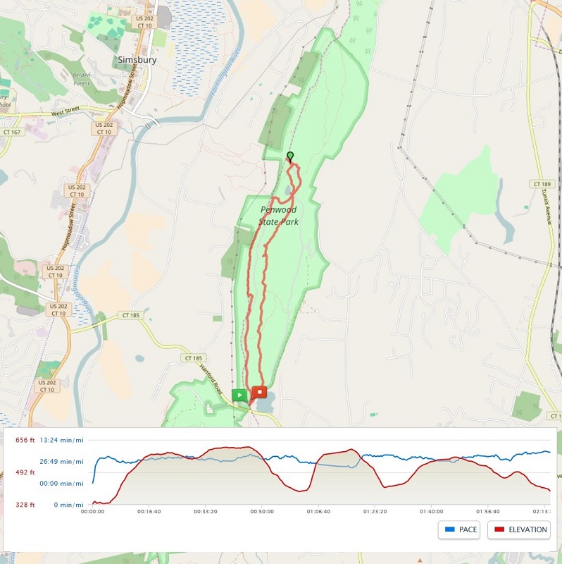
GPS Route from the MapMyHike app using OpenStreetMap.


I thought I had turned my MapMyHike app on before we started, but it didn't register and we were about 3/4 of a mile in before I realized it (that's why I am using the mileage listed in the Walk Book).

Whenever I think about hiking along this section of the trail, I think of an initial climb to gain the ridge and then level trail until the climb down at the end.  That is not really what happens (which you can see by looking at the red elevation line at the bottom of the map above), but the trail is still not that difficult.  The most challenging part is at the start/end in East Granby.  However, when you have a nice group of people to talk with along the way, you barely notice when you are climbing.

Not long after we started the hike, we came to an old chimney on the east side of the trail.  There was a bench nearby (I think there used to be more).  I don't know if this was part of an old cabin or was built as a free-standing structure.  I tried to do a little research, but did not come up with anything.


As we hiked along, there were some great westerly views of Manitook Mountain in Granby. In the picture below, you can see the cliff that is located near the bike trail that goes by the other end of Phelps Road.


We came to several overlooks on our way south.  They are difficult to see in the picture below, but the Barndoor Hills are visible just below the horizon in the middle of the photo.


And while the views may be why most people take this hike, there are plenty of other interesting things to see along the way.  We had some great discussions about various trees - telling white oak, from red, and the different types of white and red oak.  Did you know that black oak is a type of red oak?  Or that there is something called chestnut oak (part of the white oak group)?  We were also on the lookout for witch hazel.  I believe we found it, but with no flowers, there was some discussion.  We also saw quite a few mushrooms, including the Sulphur Shelf, that I think is so cool.

The rocks that make up the ridge are really interesting.  I think we take them for granted when we are standing on them looking out at the spectacular view.  In a couple of places, rocks jut up along the trail, and then you can really get a sense of how amazing they are.  These are the result of volcanic and then earthquake activity.  


Traprock

This was truly a spectacular day to hike.  The air was crisp.  The sky was sunny.  And the leaves on the trees were really amazing.


Our final viewpoint was at Peak (aka Copper) Mountain.  From here, you can look south along the ridge and see Talcott Mountain and the Heublein Tower in the distance.

Talcott Mountain in the distance.

Thank you to the folks of the East Granby Land Trust for inviting me to join them.  I had a great time and look forward to future hikes together.


Monday, October 17, 2016

Hike #49: McLean Game Refuge - Granby/Simsbury, CT

Date Hiked: Tuesday, October 11, 2016
Estimated distance: 6.02 miles
Weather: 55°F, sunny
Resources: McLean Game Refuge Map
Highlights of the trip:  fall colors
Progress toward 2016 hiking goals:  49/52 hikes; 186.15/250 miles; 31.37/25 miles on Tunxis Trail


Today, I worked on my quest to see how the trails in the main part of McLean Game Refuge connect to those over near Broad Hill Road.  I wrote about my Broad Hill Road hike (#44) and how I went part way on the white-blazed Eddy Loop Trail.  If I had continued I would have ended up on Firetown Road.  In this hike, I started on Canton Road, hiked through the main part of the Refuge over to the corner of Barndoor Hills and Simsbury Roads.  I crossed Simsbury Road and hiked over to the parking area on Firetown Road.  By wallking just a short distance on Firetown (I could see the sign), I could connect to the Eddy Loop Trail and keep on going over to Broad Hill Road.


The field in the main part of the Refuge just before heading down to Barndoor Hills Road.

After crossing Simsbury Road, I climbed up and over a small hill and wound my way down to a small field.  Pretty view with the trees changing color.


I continued over to Firetown Road and crossed over to look at the (non-existent) waterfall.  The Eddy Loop was just up the road to the right.


After looking at the waterfall, I headed back.  It is a really nice trail and I wonder how much it gets used.  I saw no one out here today.


I think my next step will be to have a friend join me so we can spot our cars and hike all the way through from Broad Hill to Canton.  Based upon my out and back mileage for this hike and the one on Broad Hill, I am guessing a through hike would be a little over 6 miles.

Hike #48: Penwood State Park - Bloomfield, CT

Date Hiked: Monday, October 10, 2016
Estimated distance: 4.43 miles
Weather: 53°F, sunny
Resources: Penwood State Park, Trail Map
Highlights of the trip:  view
Progress toward 2016 hiking goals:  48/52 hikes; 180.13/250 miles; 31.37/25 miles on Tunxis Trail


Another beautiful October day!  It has been almost a year since I have been to Penwood, and with the foliage starting to show, I figured it was time for another trip.  Last time, I thought I had hiked 6.5 miles, but since I took the same route today and it was under 5 miles, I was obviously mistaken.  I think I used the trail map to figure mileage last time and must have double counted the stretch along the Metacomet.


The above map comes from my MapMyHike app.  I wish I could get a screenshot zoomed in closer, but then I don't get the whole map.  I like the detail that the OpenStreetMap provides, but as far as I can tell, I do not have the option to view it that way while I am hiking.  Once I get home and check the hike on the computer, I can change the map options to OpenStreetMap.

Along the Metacomet Trail.

Part way along the Metacomet Trail, there is a little area off to the side where people have stacked rocks.  It is really interesting.  I believe there are little notes tucked in between some of the rocks in remembrance of loved ones.


The trail took me down to the road (closed to cars) near Lake Louise.


From Lake Louise, I continued on the Metacomet and climbed the "stairs" up to the Pinnacle.  The view up here is tremendous.  Looking south along the ridge, I could see the Heublein Tower in nearby Talcott Mountain State Park.  To the left of that, I could make out a series of hills in the distance.  It was funny, but my PeakFinder app wasn't labeling all of them.  From west to east, I think I was seeing Lamentation Mountain, Beseck Mountain, and Mount Higby.  Not 100 percent sure, but that's my guess.

Looking south at Talcott Mountain and the Heublein Tower.

I took the road down from the Pinnacle and continued to follow it past Lake Louise and around the west side of the park.  I left the road to go a short distance on the yellow trail which also offered some nice views of the valley.


I recommend taking the Metacomet, at least in one direction, to avoid some of the "crowds".  The parking lot was pretty full when I arrived and jam-packed when I got back, with people parked up on the grass.  I saw only two people while I was on the Metacomet and only a couple more at the Pinnacle.  Along the road and yellow trail, I saw quite a few more, but the vast majority of people must keep to the road on the east side of the park.

A very nice hike, and one that I should do more often.