Monday, April 25, 2016

Hike #25: D.A.R. State Forest - Goshen, MA

Date Hiked:  Saturday, April 23, 2016
Estimated distance round-trip: 4.29 miles
Weather: 59°F, sunny
Resources: DAR State Forest, Trail Map,
Highlights of the trip:  Walk along lake
Progress toward 2016 hiking goals:  25/52 hikes; 91.01/250 miles; 13.6/25 miles on Tunxis Trail**

Today, I went hiking with a friend and her husband.  They live in Agawam, so it seemed like a good opportunity to knock off another of my hiking goals:   Visit a "new-to-me" state park or forest in Massachusetts.  We chose the D.A.R. (Daughters of the American Revolution) State Forest in Goshen.


The night before we went, I saw that the state had closed the park early last fall so that they could begin work on the dam on Upper Highland Lake.  There was no indication that the park had re-opened, it just said, "see you next spring".  Hmm.  I poked around on the internet, hoping to find more information, but didn't find any.  We took our chances.  We got up to the main entrance and it was closed.  It looked newly paved, though, so I assume it will be open soon.  We drove around the north end of the park and down West Road (spectacular views to the east) and parked near the gate at Moore Hill Road.

Starting at this end, put us close to the fire tower.  On the way up, a brush truck (small fire department truck) passed us going in the opposite direction.  It passed us again a few minutes later going back with a pickup truck behind it.  They must have gone down to let the other truck in the gate.  When we got to the tower, there were several fire vehicles there and the men were up in the tower.  This was a real fire tower viewing station, not like the other fire towers I have seen locally that are just a viewing platform.  With the firemen up above and a "No Trespassing" sign below, I wasn't going to go up.  (Although looking at the state website, it says "Climb the Goshen fire tower for spectacular views of the Connecticut River Valley and into five states.")  Oh, well.


Before getting to the tower, we had run into a mountain biker who suggested we take the Long Trail down to the lake.  He even waited for us at the tower to show us the correct trail.  The trails are marked in some spots, but not in others and are not separately color coded.  It does become a little confusing.


A small stream near Upper Highland Lake.

We walked along the lake shore, which was very pretty.  We came to a small beach that is only available for people who are camping.


Upper end of Highland Lake looking toward dam.
When we got down to Moore Hill Road, we had the choice of taking the road back or following the New England Mountain Bike Association Trail, which had been suggested earlier by the biker we met.  Because it was already 4:45 p.m. and it was going to take me an hour and a half to get home, we opted for the road.

We didn't even scratch the surface of the trails available here.  I think it would definitely be worth a return trip, especially in the fall.  And now that I know that the state's own website suggests you climb the tower, I will make sure I do!

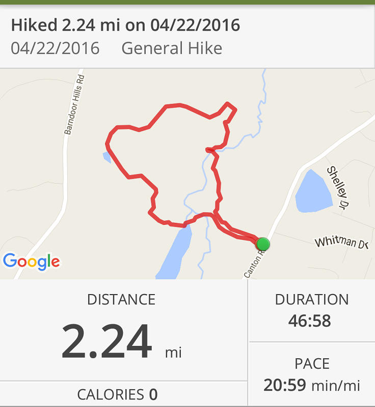

Hike #24: McLean Game Refuge - Granby, CT

Date Hiked:  Friday, April 22, 2016
Estimated distance round-trip: 2.24 miles
Weather: 75°F, cloudy
Resources: McLean Game Refuge Map
Highlights of the trip: nice walk in the woods
Progress toward 2016 hiking goals:  24/52 hikes; 86.72/250 miles; 13.6/25 miles on Tunxis Trail**


Not too much to report.  I managed to get out for a quick hike in the game refuge.  It was warm, but overcast.  Rain expected later.


Tuesday, April 19, 2016

Hike #23: Tunxis Trail (Indian Council Caves) - Barkhamsted, CT

Date Hiked:  Sunday, April 17, 2016
Estimated distance round-trip: 3.85 miles*
Weather: 60°F, bright, sunny day
Resources: CFPA Interactive Trail Map
Highlights of the trip: caves
Progress toward 2016 hiking goals:  23/52 hikes; 84.48/250 miles; 13.6/25 miles on Tunxis Trail**


I have completed the first section of the Tunxis Trail, and am over half way to my goal of 25 miles!


Rats.  I forgot to start GPS.  Parked near Legeyt Road.
We left one car at the parking lot on Ratlum Road and drove up to Legeyt Road to start.  It seems kind of funny to me, but no one else parked on Ratlum Road.  Instead, they squeeze into the area on the side of 219 and then have to try and back out on to that busy road.  Also, no one else parked at Legeyt for the easy walk into the caves.

We walked down the forest road, freshly widened and graveled from tree work in the area.  We came to the pond we saw at the end of last week's hike and continued on to another.  There were a couple of old cellar holes nearby.


Shortly after, we turned right to the caves.  While not real caves, the boulders are still pretty impressive.  Think about them traveling along in a glacier and being left behind.  Pretty cool.

Indian Council Caves.
We climbed to the top of the boulders and had the place to ourselves.  There is not really much of a view from the top, mostly the tops of trees, but without the leaves, we could see one of the ponds.


View from top of boulders.
We were lucky to get the caves to ourselves.  It was a beautiful day and as we headed south on the trail, we ran into a slew of other hikers.  Everyone was very friendly and we had conversations with a couple of people as we crossed paths.

Another excellent hike with well-marked trails.  A little wet in spots, but nothing we couldn't navigate.  On to the next section which will take us to a view over Lake McDonough.


*Curses!  I forgot to start the GPS tracker when we left the car!  Using the website, Map My Hike, I was able to use the "Create a Route" feature to estimate that I had gone a mile before turning on the tracker. 

**I will true-up the distance on the Tunxis when I finish the next section.  We completed the northern most section in the Walk Book (Route 219 to the Massachusetts State Line), which is listed as 12.6 miles.  We also did part of the next section because we parked on Ratlum Road rather than deal with the limited parking on 219.  I estimate this added a mile.

Monday, April 18, 2016

Hike #22: People's State Forest - Barkhamsted, CT

Date Hiked:  Saturday, April 16, 2016
Estimated distance round-trip: 6.17 miles
Weather: 60°F, bright, sunny day
Resources: American Legion and People's State Forest, Trail Map
Highlights of the trip: beautiful day, views of river and Riverton
Progress toward 2016 hiking goals:  22/52 hikes; 80.63/250 miles; 10.1/25 miles on Tunxis Trail


I parked in the main parking lot at the Matthies Grove.  There was no one manning the booth to collect fees this early in the year (but the restrooms were open).

I crossed the street and took the trail up to the Stone Museum (closed and boarded up) and turned left to follow the Robert Ross trail to the overlooks.  One of the overlooks listed on the map is the Gothic Window Overlook.  There may have been an overlook there at one time, but the trees have grown up.  It is fairly young growth, so maybe it gets cleared out periodically. 

Shortly after I came to a large outcropping of rock looming above me.  It looked like other people may have tried climbing to the top, but I decided not to.  I knew there were good lookouts ahead that were free of trees.

Large outcropping shortly after Gothic Window Lookout.

Having done some climbing already, I was dismayed to see yet another descent.  I know I still have to climb to the overlooks, so I don't want to go down!


No.  I don't want to go down!

I did go a few feet down the Falls Cutoff Trail to take some pictures, though.  Not a whole lot of water, but still pretty.

Stream at Falls Cutoff.

I climbed to the first really good overlook.  Funny how the overlooks with the best views don't have names, but the one with no view does. (Actually looking at the trail description, they may be the Chaugham Lookouts).  When I got to the overlook there was a group of hikers already there.  They had taken a water break and were loading up full packs.  I asked them if they were training and it turns out they were Boy Scouts training for their trip to Philmont.  The views here were spectacular.  You could see the river down below and the mountains in the distance. 


Looking southeast at West Branch of Farmington River.

I left the Robert Ross Trail and took the Jessie Gerard Trail to the next overlook and came to another group of Boy Scouts. At this overlook, you can see the town of Riverton to the north.


Riverton
Continuing on the Jessie Gerard Trail I passed the pair of glacial erratics (Veeder Boulders) and came out on Greenwoods Road near the Big Spring camping area (outhouse available).


I walked down Greenwoods Road a little bit until I came to the Charles Pack Trail on the left.  I followed this down to Beaver Brook Road crossing a pretty stream with moss covered rocks.

Stream on Charles Pack Trail.
My plan had been to continue on the Charles Pack Trail, following it all the way down to the start, but I was starting to feel like I wanted to head back.  I ended up taking Beaver Brook Road to Greenwoods and picking up the Robert Ross Trail near the end to finish my hike.  The difference in distance between taking the trail and the road was probably not significant, but I was able to pick up my pace on the road.

This was an excellent hike and even though I took the road back, I was happy to have logged over 6 miles.

Sunday, April 17, 2016

Hike #21: McLean Game Refuge - Granby, CT

Date Hiked:  Friday, April 15, 2016
Estimated distance round-trip: 4.67 miles
Weather: 55°F, bright, sunny day
Resources: McLean Game Refuge Trail Map
Highlights of the trip: beautiful day, pond
Progress toward 2016 hiking goals:  21/52 hikes; 74.46/250 miles; 10.1/25 miles on Tunxis Trail

Another gorgeous day that had to be taken advantage of.  I went to the game refuge again, going in at the Canton Road entrance.  I walked along the woods road between Spring Pond and Trout Pond and then turned onto another road and took the North Trail over to the Blue Loop.


The Blue Loop climbs to the top of a hill that, right now without the leaves, allows you to see over to the Barndoor Hills.

View to Barndoor Hills.
The Blue Loop is joined first by the Orange Loop and then by the Red Loop trails and travels along the brook that runs between the game refuge and Salmon Brook Park.  There is a side trail that takes you into the park near the pond.

Salmon Brook
The three loop trails come out near Trout Pond in the refuge.  As I walked along the edge of the pond, I could see this ropy material in the water.  It looked kind of like frog eggs, but not what I am used to seeing.  I guess it could be frog eggs, but at a different stage than what I am used to seeing.  I would expect it to be more gelatinous with small black dots in it.  That is not how this appeared.

Frog eggs?  I have no idea.


Cabin at Trout Pond.
I finished the walk by following the woods road back toward Spring Pond and then up to Canton Road.

Thursday, April 14, 2016

Hike #20: McLean Game Refuge - Granby, CT

Date Hiked:  Wednesday, April 13, 2016
Estimated distance round-trip: 2.93 miles
Weather: 48°F, bright, sunny day
Resources: McLean Game Refuge Trail Map
Highlights of the trip: View from Eastern Barndoor Hill
Progress toward 2016 hiking goals:  20/52 hikes; 69.79/250 miles; 10.1/25 miles on Tunxis Trail


Too nice a day to pass up going for a hike.  I did a loop in McLean Game Refuge that took me in Canton Road, past Spring Pond, and up the hill over to Kettle Pond.  I turned left on the woods road and went to the top of the hill to the summit.  Returning from the top, I took the other section of the Summit Trail to the North Trail and out of the Refuge via the Creek Trail.


If you go out on one of the ledges, you can look north up the valley.  


From your position on the Eastern Barndoor Hill, you can look across at the Western Barndoor Hill.  Horse farms below are on Barndoor Hills Road.


The Creek Trail takes you across a balance beam over the creek.  Okay, it's quite a bit wider than a balance beam.


 Nice mid-week hike!

Sunday, April 10, 2016

Hike #19: Tunxis Trail (Pine Mountain) - Barkhamsted

Date Hiked:  Sunday, April 10, 2016
Estimated distance round-trip: 3.85 miles
Weather: 40°F, bright, sunny day
Resources: CFPA Interactive Trail Map, Short Nature Walks in CT starting on page 13
Highlights of the trip: View to Springfield and beyond
Progress toward 2016 hiking goals:  19/52 hikes; 66.86/250 miles; 10.1/25 miles on Tunxis Trail

A nice hike on the Tunxis Trail today at Pine Mountain in Barkhamsted.  I had my hiking partner with me once again, so we were able to leave one car at Legeyt Road and took the other up to the start at Pine Mountain Road.

We debated whether to do this hike or stretch and go for the longer hike which would have included the Indian Council Caves and all the way down to the next parking area on Route 219.  In the end, we decided on the shorter hike.  For some reason, it did feel really short, maybe because we got the hardest part (Pine Mountain) over with early.


The view from Pine Mountain was quite impressive.  On the far left, we could see the white steeple of the church in the center of East Hartland.  We could also make out Springfield, MA in the distance.  I don't know how far beyond that we were seeing.  (I really need to check out the PeakFinder App).

Little white dot on left is East Hartland church steeple.

Metacomet Ridge?

We came across two Geodetic Survey markers.  The first one was in the open area at the top and the other was off to the side, just as we were about to head down the trail.


We descended and reached the other end of Pine Mountain Road.  We continued on the trail until we came to the pond at Roaring Brook.  We could see a beaver lodge and there were a couple of geese out on a little tuft of grass in the middle.  The trail looks like it splits with one way going over a bridge near the pond.  I believe the other way just goes a little farther down the brook and then connects back to the same trail.


Pond at Roaring Brook.

A short distance on, we came to the woods road that would take us back to the car we parked at the end of Legeyt Road.  There has obviously been some work done here recently.  The last time I was here, the road was much more overgrown.  A lot of gravel has been laid down and it is fairly wide.  (Taking the woods road in the other direction would lead to the Indian Council Caves).


Pond along woods road.
A good hike on a beautiful day.  We probably could have gone a little longer and done the caves, but we'll just save those for next time.