A new year and time for a fresh start.
1. Take 52 hikes.
I recently came across a website called 52 Hike Challenge. I like the idea, but I don't use social media and that seems to be a big part of how it works. Instead, I will just use the idea of challenging myself to complete 52 hikes.
2. Hike for 250 miles.
In 2015, another CT hiker set a goal of 500 miles for 2015 and he reached his goal! It is pretty inspiring, but if I think 52 hikes is a reasonable number of hikes for the year, then I would have to hike almost 10 miles/hike to reach his goal and I think that is not likely. I think 5 miles/hike is more reasonable for me which comes out to 260 miles. I made it 250 just because it seems a "rounder" number. We'll see how this year goes, and I will take it into account when determining next year's goal.
How will I keep track? Although I have used other apps, they each had different problems. I have started using MapMyHike. It has a nice dashboard that keeps track of total miles and it also draws a map of the hike.
3. Hike at least 25 miles of the Tunxis Trail
This really shouldn't be too hard, but I would prefer to have someone to hike with or at least have someone willing to help with transportation. I'd like to leave my car at the end of a section and only have to hike in one direction.
4. Visit Bash Bish Falls (Massachusetts)
I'm planning this one for the spring when the flow will be highest (assuming we get snow).
5. Hike Mount Monadnock (New Hampshire)
I'd like to do this in September or October. That will give me time to train and it's a nice time of year to see the autumn colors.
6. Visit a "new-to-me" state park or forest in Massachusetts (Bash Bish does not count).
7. Hike on the Appalachian Trail
I'm thinking of hiking along the Housatonic River.
Sunday, January 3, 2016

Sunday, November 8, 2015
Penwood State Park - November 8, 2015
I don't know how long this weather is going to last, so I have to take advantage of it. Today I took a 6.5 mile hike at Penwood State Park in Bloomfield, CT. I have been to Penwood several times before, but have never hiked on the Metacomet Trail. I decided I would do that today.
After walking along the paved road next to Gale Pond, I turned left onto the Metacomet and immediately started climbing. There was a little up and down here, but eventually it leveled out. The trickiest part was that the trail had a lot of loose rocks and there were a lot of leaves covering the trail. It made for rather treacherous footing and made me regret not bringing my hiking poles.
Along this section of trail, I found an area where people had created rock sculptures. This also seemed to be a place where people created little memorials to loved ones, either people or pets. I saw two photographs wrapped in plastic bags tucked in among the rocks.
The Metacomet meets the paved road near Lake Louise.
From Lake Louise, I planned on hiking up to the Pinnacle. There are two ways to climb up. You can either continue on the Metacomet or you can take an old road. I chose to go up on the Metacomet and come back along the road. The Metacomet is more direct, but steeper. There are rock steps placed into the hill to aid the climb.
The climb was worth it. It got washed out in the picture below, but the Heublein Tower in Talcott Mountain State Park was visible on one of the peaks looking south along the ridge.

The best of the fall colors have gone by, but it was still quite beautiful. The park was quite busy with other hikers, runners, and mountain bikers. Everyone out making the best of another gorgeous fall day.
After walking along the paved road next to Gale Pond, I turned left onto the Metacomet and immediately started climbing. There was a little up and down here, but eventually it leveled out. The trickiest part was that the trail had a lot of loose rocks and there were a lot of leaves covering the trail. It made for rather treacherous footing and made me regret not bringing my hiking poles.
Along this section of trail, I found an area where people had created rock sculptures. This also seemed to be a place where people created little memorials to loved ones, either people or pets. I saw two photographs wrapped in plastic bags tucked in among the rocks.
 |
| Rock sculpture and memorial. |
 |
| Lake Louise |
 |
| Steps leading to the Pinnacle along the Metacomet. |

The best of the fall colors have gone by, but it was still quite beautiful. The park was quite busy with other hikers, runners, and mountain bikers. Everyone out making the best of another gorgeous fall day.
Mary Edwards Mountain Property - October 18, 2015
Hike of a little over two miles on the yellow trail of Granby Land Trust's Mary Edwards Mountain Property.


Stone Valley Trail (East Side) - October 3, 2015
This hike is located in Colton, NY.
We didn't have a lot of time for a hike today, so we decided to just go as far as we had time for and turn around. We lucked out and got an absolutely beautiful autumn day. The river, falls and foliage were all spectacular. The entire family agreed this was well worth the visit, and we wished we had more time.

We parked on Riverside Drive in Colton (just a little north and across the river from the intersection of 68 and 56) near the fire station. There is a small parking lot at the turn-around at the end of the street, but it was pretty full when we got there. This is the southern starting point for the trails on the eastern side of the river. Using a PDF map of Stone Valley from Potsdam.edu, which had numbered points of interest, we hiked almost to #5 (High Terrace) before turning around.

The trail was well marked with signs that gave a little information about the river and also showed you where you were along the trail. This was especially helpful to us since we had limited time and wanted to make the most of it.

A great hike that allowed us to get out and enjoy the scenery without a large time commitment.
Monday, October 5, 2015
UK Trip: Downhill Demesne, Mussenden Temple, and Foyle Hovercraft, Northern Ireland (July 24, 2015)
On our last day by ourselves, we visited a stunning location along the coast. Downhill Demesne was a large mansion built in the 18th century and later used to billet troops during WWII. It seemed sad that the place had been in use until fairly recently and was now just a ruin.
After we walked through what was left of Downhill House we continued walking out to the cliff edge to Mussenden Temple.

After leaving Downhill Demesne and Mussenden Temple, we headed inland to Limavady and Foyle Hovercraft. I thought this activity would appeal to one boy in particular, and I was right. We all tried out the hovercrafting and then the guys tried out the powerturn buggies while I watched.


After our hovercraft adventure, we made our way to County Tyrone to meet up with family and eat more food than I ever thought was possible! It was fantastic to meet the people I had been hearing about and corresponding with for the past several years. We visited family farms and took a trip down to the old homestead in County Armagh. A dream realized. Too bad the weather couldn't have held out for one more day! We spent one full day with family and then left the next morning to get to Dublin for our flight home.
I truly appreciate the hospitality we were shown. Everyone was so welcoming. Meeting these wonderful people, these family members, made this trip a dream come true!
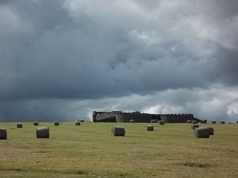 |
| Downhill House. |
 |
| At one time a horse and carriage could circle around the Temple. |

After leaving Downhill Demesne and Mussenden Temple, we headed inland to Limavady and Foyle Hovercraft. I thought this activity would appeal to one boy in particular, and I was right. We all tried out the hovercrafting and then the guys tried out the powerturn buggies while I watched.


After our hovercraft adventure, we made our way to County Tyrone to meet up with family and eat more food than I ever thought was possible! It was fantastic to meet the people I had been hearing about and corresponding with for the past several years. We visited family farms and took a trip down to the old homestead in County Armagh. A dream realized. Too bad the weather couldn't have held out for one more day! We spent one full day with family and then left the next morning to get to Dublin for our flight home.
I truly appreciate the hospitality we were shown. Everyone was so welcoming. Meeting these wonderful people, these family members, made this trip a dream come true!
UK Trip: Carrick-a-Rede Rope Bridge, Giant's Causeway, and Dunluce Castle, Northern Ireland (July 24, 2015)
Okay, today was a big day. We were going to be seeing the attractions that we had long been anticipating, namely the Carrick-a-Rede Rope Bridge and Giant's Causeway.
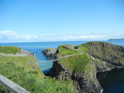
And look at the weather we got! Absolutely perfect. We started at Carrick-a-Rede. It was interesting how different the coastline here was from what we saw yesterday. Here the cliffs were made of limestone like the chalk cliffs along the south of England.

After a nice lunch along the way, we next stopped at Giant's Causeway. This seemed to be a bigger tourist attraction than the rope bridge. There were a lot of people, but you could still get a little piece of the causeway to yourself. These hexagonal basalt formations are really interesting.


Our next stop along the North Antrim Coast was Dunluce Castle. It was getting late in the day and we got in here by the skin of our teeth.


We continued on to Portrush and Avarest House, our B&B for the night. We were upgraded to a nice big room with a sitting area that allowed us nice views of the beach and harbor.

Although the B&B was very nice, Portrush was a bit too much of a holiday beach town for me. Next time, a quieter village would be my choice.
And look at the weather we got! Absolutely perfect. We started at Carrick-a-Rede. It was interesting how different the coastline here was from what we saw yesterday. Here the cliffs were made of limestone like the chalk cliffs along the south of England.

 |
| Look how sandy the bottom is. |
 |
| Crossing back over the bridge. Not as bad as some had feared. |

 |
| Some caves in the limestone cliffs. |


Our next stop along the North Antrim Coast was Dunluce Castle. It was getting late in the day and we got in here by the skin of our teeth.


We continued on to Portrush and Avarest House, our B&B for the night. We were upgraded to a nice big room with a sitting area that allowed us nice views of the beach and harbor.

 |
| View of Portrush beach from our room. |
Although the B&B was very nice, Portrush was a bit too much of a holiday beach town for me. Next time, a quieter village would be my choice.
UK Trip: Glens of Antrim and Torr Road, Northern Ireland (July 23, 2015)


After leaving Glenariff, we headed back through Cushendall and then out to the coast to Cushendun, a picturesque little village with some cool caves and Cornish-style houses.
 |
| Near the caves. |

After a nice lunch, we took the Torr Road to an overlook along the coast. More than one person warned us about the Torr Road, but I did not think it was that bad. Maybe we didn't do the worst part of it. It was a single track road, but there were no sheer drops, just beautiful scenery. If a car came from the other direction, one of us squeezed over to the side and waited for the other to pass.
The view from Torr Head up and down the coast was absolutely breathtaking. We could see Scotland only 11 miles away across the Irish Sea.
 |
| View from Torr Head. |
Subscribe to:
Posts (Atom)