Thursday, March 30, 2017

2017 Hike #11: McLean Game Refuge - Granby, CT

Date Hiked: Wednesday, March 29, 2017
Estimated distance:  2.24 miles
Weather: 50°F, scattered clouds
Resources: McLean Game Refuge, Trail Map
Highlights of the trip:  pond
Progress toward 2017 Outdoor Goals:  11/52 hikes; 32.01/250 miles hiked


My hiking partner got out of work early today and texted me to see if I wanted to join her on a quick hike.  Sure!


We decided to do a short hike in McLean Game Refuge, starting at the corner of Simsbury Road and Barndoor Hills Road.  We made a loop around Spring Pond.

You never know what you are going to find for trail conditions at this time of year.  Are the trails clear?  Is it muddy?  Is there mushy snow or have people packed it down so it is a sheet of ice?  We found a mixed bag.  For the most part, I would say we encountered shallow, mushy snow.  A little slick in spots, but we both had our hiking poles, so it wasn't too bad.


Spring Pond and cabin through the trees.

The pictures don't do it justice, but the color of the water and the snow on the hillside around the pond was very pretty.

Spring Pond

 So, thanks to my friend for getting me out of the house on this beautiful day!

Wednesday, March 22, 2017

2017 Hike #10: Holcomb Farm East Side Trails - West Granby, CT

Date Hiked: Sunday, March 19, 2017
Estimated distance:  1.82 miles
Weather: 39°F, sunny
Resources: Holcomb Farm, Trail Map
Highlights of the trip:  views over snowy fields
Progress toward 2017 Outdoor Goals:  10/52 hikes; 29.77/250 miles hiked


After my snowshoe fail the other day, I decided to try hiking without them.  I had thought about strapping the snowshoes to a pack and bringing them along, just in case.  I fumbled with strapping them on the pack and finally gave up.  I figured by picking a place where other people had packed the snow down, I would be okay without them.  People often walk their dogs on the east side of Holcomb Farm, so that was where I decided to go.


OpenStreetMap from my MapMyHike app.


Sure enough, the trail up the hill was pretty well worn.  The sun was shining and melting the snow.

Looking to the southwest from the bench.

I started to doubt myself as I made my way over to the bench at the viewpoint.  Not as many people had traveled this way and I was trying to stay in others footprints.  When I got to the bench, there was another person there on snowshoes.  He said the trails in the woods were pretty well traveled and packed down, so I thought I had made the right choice not to bring my snowshoes.


Entrance to the woods from the field with a trail sign.
No.  I had not made the right choice.  While the trails through the woods were well used, the snow was pretty mushy and hard to walk on - like walking on a sandy beach.  The trails are also narrow, and I felt bad for post holing ski/snowshoe trails.  (Although, I was not the only one who had been walking out there.)


I took the blue trail in a clock-wise direction.  I went past the first turn on to the red trail and took the second turn, which went south along an old barbed wire fence and cedar trees, to a field.  I walked across the field and back down to the road.


Today's lesson was "be prepared".  If I had strapped my snowshoes to a pack, I certainly would have put them on.  It would have been easier along the trail, and I wouldn't be hobbling around with sore calves 3 days later.  Hopefully, this is a lesson learned.


Tuesday, March 21, 2017

Snowshoe Fail

On Tuesday, March 14, our area received about a foot and a half of snow.  Thoughts of spring had to be put aside.

On Friday, I decided to dig out my snowshoes and try a little hike.  I don't think I used my snowshoes at all last year.  I thought that I'd be able to hike the 3/4 of a mile to Carpenter Falls in West Granby along Broad Hill Road.  I was wrong.

The going was tougher than I had anticipated.   I didn't want to wreck the X-Country ski tracks that someone else had made, so I was breaking my own trail.  The snow was still quite fluffy and, with each step, I sank into the snow and then pulled the snow out with my snowshoe. 

I made it about a 1/4 of a mile and decided to call it quits.  If someone else had been with me, maybe I could have motivated myself to go farther, but it just wasn't much fun.  I did enjoy being outside on a nice day - as long as I was standing there motionless!


Ostensibly taking a picture, but really taking a break.


I obviously need to get in better shape, but it probably would have helped if:
a.  I hadn't picked a hike that was on a hill (duh, Broad HILL Road),
b.  I had snowshoes designed for my current weight (I bought these a number of years ago).

In all, I went a little over 1/2 a mile, so I don't get to count it toward my hike goals (which must be a minimum of 1 mile). 


Tuesday, March 7, 2017

2017 Hike #9: Bear Hole Reservoir - West Springfield, MA

Date Hiked: Sunday, February 26, 2017
Estimated distance:  4.73 miles
Weather: 37°F, scattered clouds
Resources: AllTrails Recording, A Citizens' Guide to "Bear-Hole"
Highlights of the trip:  waterfall
Progress toward 2017 Outdoor Goals:  9/52 hikes; 27.95/250 miles hiked


I have to say this hike was a pleasant surprise.  My hiking partner's husband had suggested this location because there were quite a few geocaches for him to get.  I think both she and I were thinking, "West Springfield.  Probably not that nice a hike."  But, we went along and were quite happy we did.


We parked in a fairly large lot at the end of the paved part of Bear Hole Road off of Dewey Street.  There were a lot of dog walkers (most dogs were not on leashes), but they seemed to head for the trail that went directly around the reservoir.  We headed up the disused road and had it mostly to ourselves.  There were only a few patches of snow remaining here and there.

As far as I can tell, there are no published trail maps of the area.  We used a map we got from AllTrails (linked above) and the MapMyHike app on my phone to figure out where we were and where to go.  The New England Trail passes along the western boundary of the watershed and near Lane Quarry.  I had seen somewhere that the trail may be moved to the east side of the reservoir, but it has not happened yet.


Birch Polypore

[Note on Birch Polypore from The Audubon Society Field Guide to North American MushroomsThrough its varied history this species has been used in the absence of matches to keep fires blazing, as an anesthetic, and as a razor strop.]

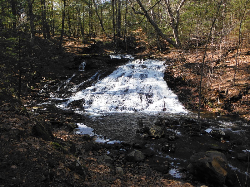
The old road continued north and under the Mass Pike, but we turned west and then south back toward the reservoir.  As we got closer to the northern end of the reservoir, we took a trail that went down to a bridge over Paucatuck Brook.  We went into the woods to get a closer look and then saw that there was a waterfall.  We found that if we backtracked, the trail would lead us around to an even better view of the falls.

Bridge over Paucatuck Brook.

Waterfall seen from north side.

What is this chimney doing on a hillside right next to the brook?

We followed the trail around to the other side which gave a much nicer view of the waterfall.  The stone chimney was in front of us on the opposite hillside.  It seemed like a strange place for a chimney.  A little research led me to discover that there used to be a resort here from 1890-1906.  There was an open air pavilion that spanned the brook and the chimney anchored one end of the pavilion.  I could not find a picture of it directly online, but if you look on the page numbered 27 (or page 30 of the PDF) of A Citizens' Guide to "Bear-Hole" there are a couple of photos there.  How cool is that?


While this waterfall is not listed in my book New England Waterfalls (I have an older version), it is on the website under A List of More Waterfalls in Massachusetts.  I can't believe the falls get only a "Fair" rating.  I thought they were were pretty nice and I will be counting them toward my waterfall goal for 2017.


View up the reservoir.
As we headed to the southern end of the reservoir, we took a detour off the trail to go out onto a concrete structure that stuck out into the reservoir.  I'm not sure what this is for.  It is close to the southern end of the reservoir, but not quite.  We got to the end of the reservoir and looped back up to our car.

This was a great hike.   The trail was relatively flat and wide the whole way around.  There are other trails that could be explored and I believe you could connect to the NET if you wanted to.  I have to admit to being pleasantly surprised by this place in the middle of busy West Springfield.

This will definitely be counting toward my waterfall goal for the year and maybe the hike to a body of water (though I was thinking of something a little more remote).


Monday, March 6, 2017

2017 Hike #8: Holcomb Farm - West Granby, CT

Date Hiked: Tuesday, February 21, 2017
Estimated distance:  2.82 miles
Weather: 44°F, overcast
Resources: Holcomb Farm, Trail Map
Highlights of the trip:  view of stream
Progress toward 2017 Outdoor Goals:  8/52 hikes; 23.22/250 miles hiked


My hiking partner had a Tuesday off, so we decided to do a local hike.  We headed over to Holcomb Farm in West Granby and hiked the trails on the west side of the farm.  I wasn't sure what we would find for trail conditions, but I had my Microspikes with me just in case.


Before we got too far, I decided to put the spikes on.  There were icy patches near the barns.  We had to pass through the gates to cross the field, and there was only patchy snow here.  In the woods, the snow was very soft and the spikes ended up accumulating snow, so off they came.

I wanted to zigzag our way to the top and back down again to get more miles, but I didn't have a trail map with me.  I ended up zigging instead of zagging, so our hike was a little shorter than intended.  Still a pretty good workout because of the soft snow.  It was just nice to get outside.

We went down as far as the bridge over Beach Brook and turned back because I was pretty sure we would not be able to cross the brook farther down.


 A nice hike.  It can be made longer by connecting to the dirt Broad Hill Road and hiking in the McLean Game Refuge or by doing the trails on the east side of the farm.  (The trails on the east side can get very muddy in the spring).